Major Winter Storm Could Bury Colorado’s San Juan Mountains Under More Than 30 Inches of Snow This Weekend With Wolf Creek Pass Closures Possible
PAGOSA SPRINGS, CO — A major winter storm is set to hit Colorado’s San Juan Mountains this weekend, with snowfall totals that could top 30 inches in the highest elevations. The first round of snow arrives Friday night into Saturday morning, but the heaviest snow is expected from Sunday morning through midday Monday. Travel over Wolf Creek Pass and Red Mountain Pass could become extremely difficult, and road closures are possible. The storm comes just days after historic rainfall caused severe flooding across the same region.
Heaviest Snow Above 11,000 Feet
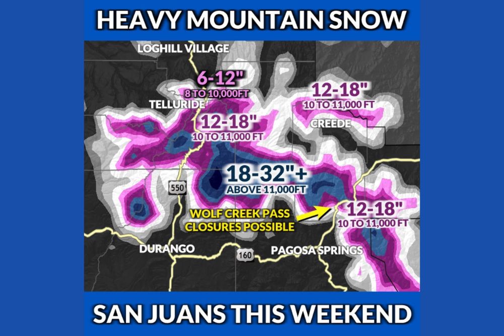
The greatest snowfall is expected in the highest peaks of the San Juan Mountains, where 18 to 32 inches or more could pile up above 11,000 feet. This zone covers the high terrain between Silverton, Lake City, and the Continental Divide, including areas near U.S. Highway 550.
Totals of this size would mark one of the most significant early-season snowstorms in recent years for the high country of southwest Colorado.
12 to 18 Inches Between 10,000 and 11,000 Feet
Slightly lower elevations between 10,000 and 11,000 feet could see 12 to 18 inches of snow. This includes areas near Telluride, Creede, and the terrain surrounding Wolf Creek Pass northeast of Pagosa Springs.
Higher ground along the New Mexico border southeast of Pagosa Springs is also expected to see 12 to 18 inches, with locally higher totals in the highest terrain.
Lighter Totals at Lower Elevations
Areas between 8,000 and 10,000 feet, including terrain near Telluride and Loghill Village, are forecast to see 6 to 12 inches of snow. Lower towns such as Durango and Pagosa Springs are expected to see much less, with rain or a rain and snow mix more likely at valley levels.
Wolf Creek and Red Mountain Passes at Risk
Wolf Creek Pass on U.S. Highway 160 and Red Mountain Pass on U.S. Highway 550 could become extremely difficult to travel. Heavy snowfall, reduced visibility, and slick roads may lead to chain requirements or temporary closures.
Drivers planning to cross the mountains this weekend should check road conditions with CDOT before traveling, carry winter emergency supplies, and consider delaying trips during the heaviest snowfall on Sunday and Monday.
Storm Follows Historic Flooding
This storm arrives after a week of record rainfall across southwest Colorado, where some areas received 4 to 7 inches of rain in just 72 hours. The San Juan River at Pagosa Springs reached its second-highest crest on record, and downstream communities in New Mexico and Utah faced major flooding and evacuations.
While the snow will lock up moisture in the mountains for now, rapid melting later could raise renewed concerns for creeks and rivers.
Good News for Ski Areas
The heavy snow is welcome news for ski resorts, including Wolf Creek Ski Area, Purgatory, and Telluride, as they prepare for the upcoming winter season.
For continuing coverage of Colorado snowstorms, mountain travel alerts, and critical weather analysis across the United States, visit Weather Radar.