Negatively Tilted Trough Could Bring Strong Storms to Mississippi and Alabama on Wednesday, November 4 but Weak Instability May Limit the Threat
BIRMINGHAM, AL — Forecasters are keeping a close eye on Wednesday, November 4, as a negatively tilted trough approaches the Deep South from the west. The system will provide strong upper-level support for severe weather across parts of Mississippi and Alabama, but instability is expected to be limited, which could hold back the overall threat. There is no formal severe weather risk issued yet, but forecasters will be watching trends closely over the coming days as the region transitions into its fall severe weather season.
Upper-Level Support Moving Into the South
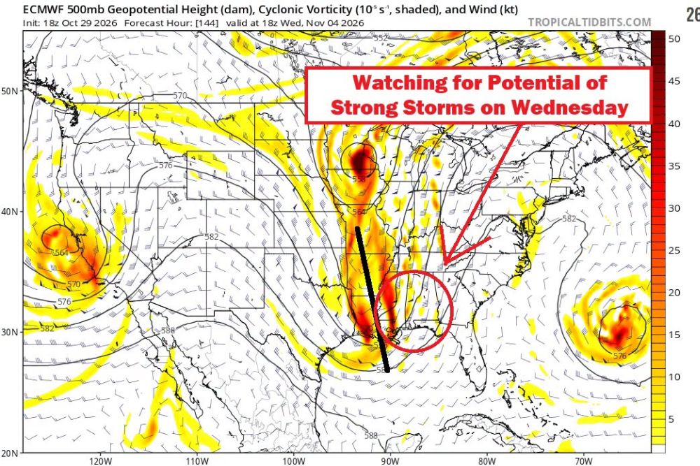
The ECMWF upper-level forecast valid for Wednesday afternoon shows a sharp trough extending from the Upper Midwest south through the Mississippi Valley and into the Gulf of Mexico. Strong areas of cyclonic vorticity, a measure of spin in the atmosphere, are shown along the trough axis near Louisiana, Mississippi, and Arkansas.
A negatively tilted trough leans from southeast to northwest and is often associated with strengthening storm systems and stronger wind fields. This type of setup can help organize thunderstorms when other ingredients are present.
Area of Concern Across Mississippi and Alabama
The area highlighted for potential strong storms is centered over central and southern Mississippi and western Alabama, extending toward the Gulf Coast. Strong winds aloft and upper-level energy moving through this region could support organized storms if enough low-level moisture and instability develop.
Instability Is the Missing Ingredient
While upper-level support appears favorable, forecasters say instability may be lacking. Instability refers to how easily air can rise and form strong thunderstorms. Without enough warm, moist air near the surface, storms may struggle to become severe even with strong winds aloft.
Late fall severe weather events in the Southeast often feature high shear and low instability, a setup that can still produce damaging winds or brief tornadoes in some cases, so forecasters will continue monitoring closely.
Other Systems on the Map
The forecast map also shows another storm system off the West Coast and a separate system spinning in the western Atlantic Ocean, highlighting an active pattern across North America heading into early November.
Fall Severe Weather Season Underway
Alabama and Mississippi have a secondary severe weather season that begins in November and continues through spring. Storms during this period often move quickly and can occur at night.
Residents should review severe weather plans, make sure weather alerts are enabled, and stay updated as Wednesday approaches.
Watching the Trends
Forecasters will continue tracking model trends between now and Wednesday to determine whether instability increases enough to support a more organized severe weather threat.
For continuing coverage of severe weather outlooks, Southern storms, and critical weather analysis across the United States, visit Weather Radar.