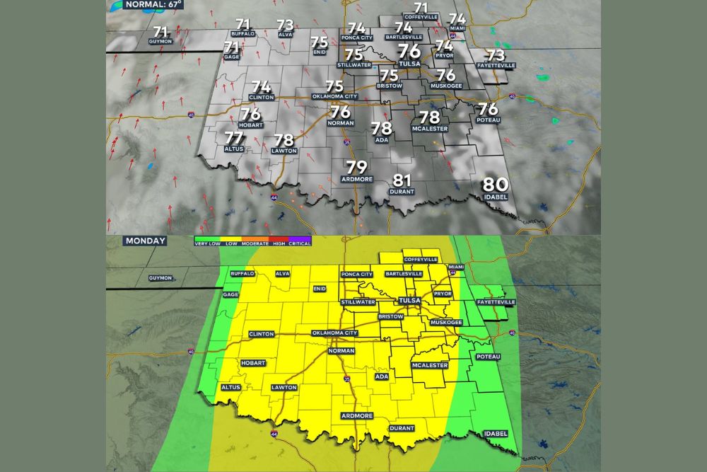
Windy and Warm Monday Pushes Oklahoma Highs Near 80 Before a Potent Storm System Brings Severe Storm Risk to Tulsa and Oklahoma City
TULSA, OK — Oklahoma is in for a pleasant Sunday, November 1, as morning clouds and patchy fog give way to clearing skies and a light south breeze by the afternoon. But changes are coming quickly. Monday, November 2, will turn windy and warm, with highs climbing into the upper 70s and low 80s, well above the normal high of 67 degrees. A potent storm system will then bring rising storm chances Monday evening, with some storms possibly becoming strong to severe into Monday night.
Warm Highs Across the State Monday
Monday’s highs will run about 10 to 14 degrees above normal across much of the state. Durant is expected to be among the warmest spots at around 81 degrees, while Idabel reaches about 80 degrees and Ardmore near 79 degrees.
Lawton, Ada, and McAlester are forecast to reach around 78 degrees, while Altus climbs to about 77 degrees. Tulsa, Norman, Hobart, Muskogee, and Poteau are expected near 76 degrees.
Northern and Western Oklahoma Stay in the 70s
Highs across northern and western Oklahoma will be slightly cooler but still warm for early November. Oklahoma City, Stillwater, Enid, and Bristow are expected near 75 degrees, while Clinton, Ponca City, Bartlesville, Pryor, and Miami reach about 74 degrees.
Alva is forecast near 73 degrees, while Buffalo, Gage, Guymon, and Coffeyville, Kansas, sit near 71 degrees. Fayetteville, Arkansas, is expected to reach about 73 degrees.
Storm Zone Covers Most of Oklahoma
Monday’s storm zone outlook places most of Oklahoma in a low risk category for strong to severe storms. This area includes Oklahoma City, Tulsa, Norman, Lawton, Enid, Stillwater, Ardmore, Durant, Ada, McAlester, Muskogee, and Bartlesville.
A very low risk area extends along the western edge of the state near Altus, Gage, and Buffalo, as well as along the eastern border near Poteau, Idabel, and Fayetteville.
Storm Timing Monday Evening Into Night
Storm chances are expected to increase Monday evening, with the greatest risk for strong to severe storms continuing into Monday night. Gusty south winds during the day will draw warm, moist air northward ahead of the approaching system, helping fuel thunderstorm development.
Storms may bring damaging winds, large hail, and possibly a tornado or two, especially in central and southwestern Oklahoma.
Prepare Before Storms Arrive
Residents should secure loose outdoor items ahead of Monday’s strong winds and make sure weather alerts are enabled on phones, especially since storms may arrive after dark.
For continuing coverage of Oklahoma severe weather, storm outlooks, and critical weather analysis across the United States, visit Weather Radar.