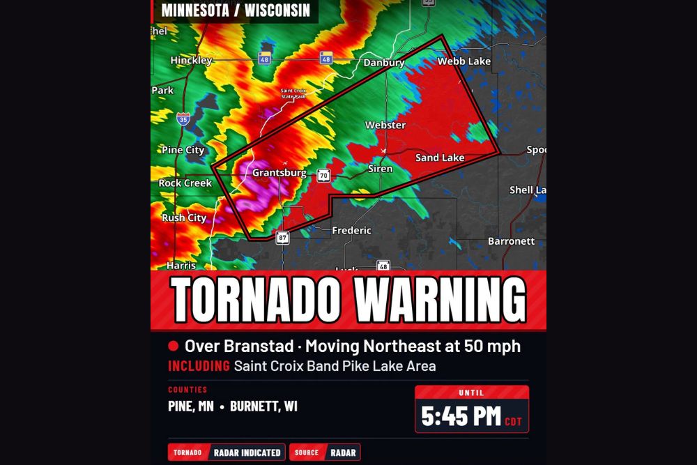
Tornado Warning Issued for Pine County, Minnesota and Burnett County, Wisconsin as Storm Races Northeast at 50 MPH Toward Grantsburg and Siren
GRANTSBURG, WI — A tornado warning was issued for portions of Pine County, Minnesota, and Burnett County, Wisconsin, after radar indicated a severe thunderstorm capable of producing a tornado near the St. Croix River. The storm was located over Branstad, about 13 miles southeast of Pine City, and was moving northeast at 50 mph. The warning was set to remain in effect until 5:45 PM CDT, with communities including Grantsburg, Siren, Webster, and the Saint Croix Band Pike Lake area in the storm’s path.
Radar-Indicated Rotation Near the St. Croix River
The warning was based on radar-indicated rotation, meaning forecasters detected signs of a rotating storm that could produce a tornado. Radar imagery showed an intense core with red and magenta returns near Grantsburg, indicating very heavy rain and possibly hail within the storm.
The fast-moving storm crossed from Minnesota into Wisconsin along the St. Croix River corridor, an area that includes Saint Croix State Park on the Minnesota side.
Communities Inside the Warning Area
The tornado warning polygon stretched from near the Minnesota-Wisconsin border northeastward across Burnett County. Communities within the warned area included Grantsburg, Siren, Webster, Sand Lake, Danbury, and Webb Lake, along with portions of State Highway 70.
Nearby communities such as Frederic, Pine City, Rock Creek, Rush City, and Hinckley were located close to the warning area and were urged to stay alert as storms continued moving through the region.
Fast Storm Motion Increases the Danger
With the storm moving at 50 mph, residents had little time to react once warnings were issued. Fast-moving storms can quickly bring damaging winds, heavy rain, and possible tornadoes to communities miles away within minutes.
Residents should take action as soon as a warning is issued rather than waiting to see or hear a tornado.
Part of an Active Late October Storm Event
The tornado warning came during an unusually active evening of severe weather across the Upper Midwest. A strong low pressure system and cold front moved across Minnesota and Wisconsin, pulling unusually warm and humid air northward for late October. Severe thunderstorm warnings were also issued farther north in Wisconsin, including near Ashland and the Michigan state line.
Safety Steps During a Tornado Warning
During a tornado warning, residents should move to an interior room on the lowest floor of a sturdy building, away from windows. Mobile homes and vehicles offer little protection, so those in such shelters should seek safer locations if time allows.
Damage Surveys to Follow
The National Weather Service will review any reports of damage or possible tornado touchdowns in the coming days.
For continuing coverage of tornado warnings, Upper Midwest storms, and critical weather analysis across the United States, visit Weather Radar.