Tornado Warning Issued as Observed Tornado Moves Toward Deming, New Mexico Monday Evening With Hail up to 1.75 Inches Along Interstate 10
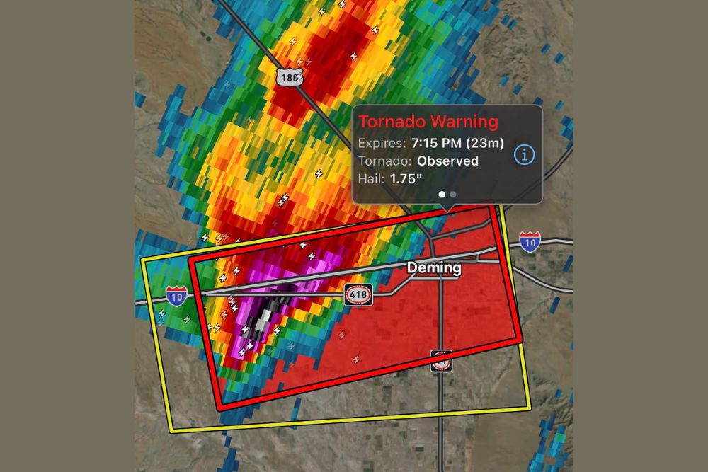
DEMING, NM — A rare October tornado warning was issued for Deming and surrounding areas of Luna County in southwestern New Mexico on Monday evening, October 19, after a tornado was observed west of the city. Radar imagery from 6:46 PM, updated at 6:51 PM, showed a powerful severe thunderstorm moving east toward Deming, carrying an impressive hail signature with stones estimated up to 1.75 inches in diameter.
Tornado Observed West of Deming
The warning listed the tornado as observed, meaning it was confirmed rather than only indicated by radar. The storm was located west of Deming near Interstate 10 and was tracking eastward toward the city at the time of the update. The tornado warning was set to expire at 7:15 PM, leaving roughly 23 minutes remaining on the alert as of the latest radar update.
The warning polygon covered a broad area stretching from the open desert west of town across Deming itself, including sections of Interstate 10, State Road 418, and areas to the south of the city. A larger severe thunderstorm warning box surrounded the tornado warning area.
Hail up to 1.75 Inches Accompanied the Storm
In addition to the tornado threat, the storm carried a strong hail signature on radar. The warning listed hail sizes of up to 1.75 inches, roughly the size of a golf ball. Hail of this size can damage vehicles, break windows, dent roofs and siding, and cause injuries to anyone caught outdoors.
Radar showed the most intense portion of the storm, marked by deep magenta and white returns, positioned along and south of Interstate 10 west of the city. These colors typically indicate very heavy precipitation mixed with large hail.
Storm Structure Showed Intense Rotation and Lightning
The storm appeared as part of a long line of strong thunderstorms stretching from the southwest toward the northeast, extending along U.S. Highway 180 north of Deming. Frequent lightning was detected throughout the storm complex, with many strikes concentrated near the strongest core.
The strongest cell at the southern end of the line displayed the classic structure associated with supercell thunderstorms, which are capable of producing tornadoes, large hail, and damaging winds. The southern end of a storm line often holds the most organized rotation, as it has access to the most unstable air.
Travel Impacts Along Interstate 10
With the storm moving directly along the Interstate 10 corridor, drivers traveling between Lordsburg, Deming, and Las Cruces faced dangerous conditions. Heavy rain, hail, reduced visibility, and strong winds can make roadways hazardous within minutes.
Motorists caught in such storms are advised never to shelter beneath highway overpasses. Instead, drivers should pull off the road if possible, or seek sturdy shelter at a nearby building when time allows.
Rare October Severe Weather for New Mexico
Tornadoes are relatively uncommon in southwestern New Mexico, particularly in October. The event highlights the growing storm activity across the Southwest as a more active weather pattern sets up across the western United States heading into the final weeks of the month.
Safety Reminders for Residents
Residents in Luna County and nearby communities should stay informed through the National Weather Service and local alerts as storms continue across the region. During any tornado warning, people should move to an interior room on the lowest floor, away from windows, and protect their heads from flying debris.
Any damage reports, storm surveys, or official tornado ratings will come from the National Weather Service in the coming days.
For continuing coverage of severe storms, tornado warnings, and critical weather analysis across the United States, visit Weather Radar.