El Niño Tilts November Toward Above Normal Rain Across Georgia, Alabama, Louisiana and Florida as Michigan and Ohio Lean Drier Than Usual
ATLANTA, GA — The latest November precipitation outlook from the Climate Prediction Center leans wetter than normal across much of the Southeast, signaling a possible turnaround after weeks of dry weather. With El Niño beginning to strengthen in the Pacific Ocean, an increasingly active southern jet stream could steer several storm systems across the region next month, potentially bringing some soaking rains to areas that have struggled with dryness.
Strongest Wet Signal Along the Gulf Coast
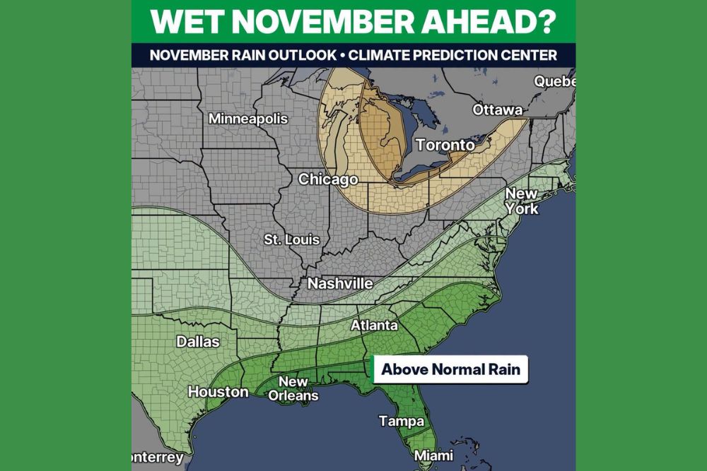
The highest odds of above normal rain are centered across the Gulf Coast and the Deep South. This zone includes southern Louisiana, Mississippi, Alabama, Georgia, northern and central Florida, and parts of South Carolina. Cities such as New Orleans, Tampa, and areas just south of Atlanta fall within the strongest portion of the wet signal.
This pattern is typical of El Niño winters, when the jet stream often dips farther south and directs repeated storm systems from Texas across the Gulf states and into the Southeast.
Wetter Odds Extend From Texas to the Northeast
A broader area of leaning wet conditions stretches well beyond the core zone. Much of Texas, including Dallas and Houston, is favored for above normal precipitation, along with Atlanta, the Carolinas, and Virginia. The wetter signal also extends northeastward along the Appalachians and the East Coast toward New York and parts of New England.
South Florida, including Miami, sits on the outer edge of the wetter zone, with somewhat lower confidence than areas farther north along the peninsula.
Drier Signal Around the Great Lakes
Not every region is expected to turn wetter. The outlook shows a leaning dry zone centered over Michigan, northern Indiana, northern Ohio, and parts of Pennsylvania and western New York, extending toward Toronto and Ottawa. Areas near Chicago sit near the edge of this drier signal.
Meanwhile, much of the Midwest and Ohio Valley, including Minneapolis, St. Louis, and Nashville, shows equal chances, meaning no strong tilt toward wetter or drier than normal conditions.
A Big Contrast to Recent Dry Weather
The outlook offers potential relief for parts of the Southeast that have dealt with a long stretch of dry weather this fall. Many communities have seen expanding drought conditions, elevated fire danger, and stressed crops and pastures. A wetter November could help replenish soil moisture, ponds, and local water supplies.
However, heavy rainfall after a long dry spell can also lead to rapid runoff, as hardened soils absorb water slowly. Residents in flood-prone areas should stay alert to forecasts once the pattern begins to shift.
Outlook Shows Odds, Not Guarantees
Seasonal outlooks indicate probabilities rather than specific forecasts. A wetter than normal signal means the odds favor above average rainfall for the month as a whole, but it does not predict the timing or strength of individual storms. Dry stretches may still occur between systems.
El Niño shifts the odds toward a more active storm track, but day-to-day weather will depend on how each system develops as November unfolds.
What Residents Should Watch For
Residents across the Gulf Coast and Southeast should monitor short-range forecasts closely as the calendar turns to November. If the pattern verifies, the region could transition from one of its driest stretches of the year to a much more active and rainy period.
For continuing coverage of seasonal outlooks, El Niño developments, and critical weather analysis across the United States, visit Weather Radar.