Wet Halloween Possible for Dallas and North Texas as Growing Forecast Signals Point to Showers and Thunderstorms Hitting Trick or Treat Plans
DALLAS, TX — The latest forecast signals are raising concerns across North Texas, where a wetter and more active weather pattern may be taking shape just in time for Halloween on Saturday, October 31. Both major global ensemble models are increasingly favoring showers and thunderstorms across the region, raising the possibility that rain could affect trick-or-treating plans. While the holiday is still about nine days away and details may change, the growing signal for unsettled weather heading into late October is becoming harder to ignore.
Rain and Storms Shown Across Much of Texas
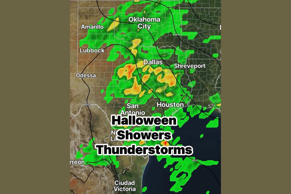
Forecast guidance shows a broad area of showers and thunderstorms spreading across central and eastern Texas around Halloween. The heaviest activity, marked by yellow and orange returns, appears focused near and southwest of Dallas, extending through North Central Texas and into areas east of the Metroplex toward East Texas.
Additional rain extends northward into Oklahoma, including areas near Oklahoma City, and southward toward San Antonio, Houston, and the Texas Gulf Coast. Scattered showers are also shown near Shreveport in northwest Louisiana.
Western Texas Sits on the Drier Side
Areas farther west, including Lubbock and Odessa, appear on the drier edge of the system based on current guidance. Amarillo and the Texas Panhandle show some scattered showers, though coverage appears lighter than across central and eastern portions of the state.
The placement of the rain shield could still shift significantly over the coming days as forecast models adjust to new data.
Growing Signal for an Active Pattern
The developing pattern reflects a stronger flow of moisture into Texas as storm systems move across the Southern Plains. An active southern jet stream, often linked to El Niño conditions, has been helping steer storm systems across the region this fall.
North Texas has already experienced a wet October, with more than 3.9 inches of rain recorded at Dallas/Fort Worth International Airport earlier in the month. A wet Halloween could push monthly totals even higher.
Timing and Coverage Still Uncertain
With the holiday still more than a week away, it remains too early to determine exact timing, coverage, and storm intensity. Rain could arrive during the day, in the evening during trick-or-treating hours, or shift earlier or later depending on how the pattern evolves.
Residents should expect forecasts to become more detailed over the next several days as the event draws closer and confidence improves.
Planning Ahead for Halloween
Families with Halloween plans should keep an eye on the forecast and consider backup options, such as indoor parties or trunk-or-treat events at churches, schools, and community centers. Waterproof costumes, umbrellas, and rain jackets may become useful accessories if showers move through during the evening.
If thunderstorms develop, outdoor activities should be paused until lightning moves out of the area.
Stay Tuned for Updates
The signal for unsettled weather continues to grow, but there is still time for the forecast to change. Residents across North Texas should keep the umbrella nearby and check back for updates as Halloween approaches.
For continuing coverage of Halloween forecasts, Texas storm updates, and critical weather analysis across the United States, visit Weather Radar.