Powerful Pacific Storm Packed With Jet Stream Energy Could Bring Moderate to Significant Snow to Colorado Mountains Next Weekend Around November 1
DENVER, CO — A powerful storm system loaded with jet stream energy is expected to move onshore from the Pacific Ocean next weekend, potentially bringing moderate to significant snow to Colorado’s mountains. The storm’s origins can be traced far out into the Pacific, northeast of Hawaii, where it is beginning to take shape. Early forecast guidance shows strong agreement that the system will impact the Rockies, though important details such as the storm’s track, timing, and exact impacts remain uncertain.
Strong Jet Stream Energy Moving Inland
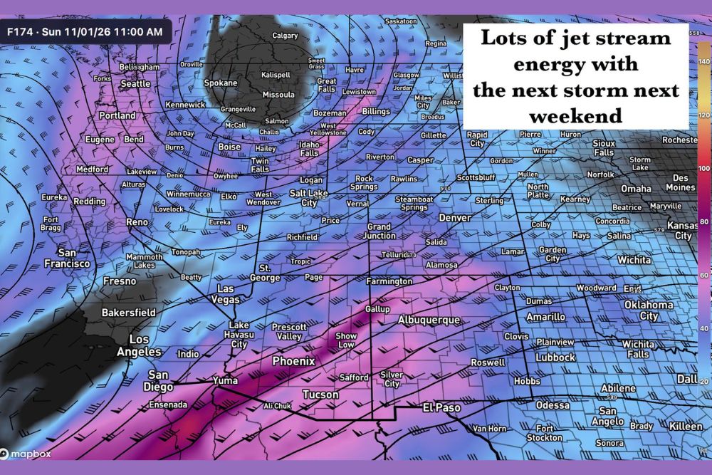
Forecast model data valid for Sunday, November 1, at 11:00 AM shows a powerful band of jet stream winds sweeping across the Southwest and into the Four Corners region. The strongest upper-level winds stretch from Southern California across Arizona, New Mexico, and southern Colorado, with high-speed winds extending toward Texas and Oklahoma.
This strong jet stream energy can help intensify storm systems as they move inland, increasing the potential for heavy precipitation and gusty winds across the mountains and nearby lower elevations.
Euro Ensemble Shows Strong Snow Signal
The European ensemble forecast suggests that moderate to significant snow accumulation is possible across Colorado’s mountains. Notably, all 50 members of the Euro ensemble show some probability of snow accumulation, a strong sign that a snow-producing storm is likely to affect the high country.
When nearly every member of an ensemble forecast agrees on an outcome, forecasters typically gain more confidence that a significant event will occur, even if the details are still being refined.
GFS Model Still Struggling With Details
The GFS model also shows the same storm developing, but its individual runs have varied considerably on key details. Differences in the storm’s track, strength, and timing make it difficult to pin down exact snowfall totals and impacts at this point.
Forecasters say it is still too early to determine which mountain ranges will receive the heaviest snow or whether lower elevations, including the Front Range cities, could see any accumulation.
Areas to Watch Across the West
Based on current guidance, areas across the San Juan Mountains, Central Mountains, and Northern Mountains of Colorado could all see snow. Ski areas near Telluride, Steamboat Springs, and the Interstate 70 corridor may benefit from early-season snowfall.
The storm could also bring wet weather and mountain snow to parts of Utah, Arizona, and New Mexico, following a week of historic rainfall and flooding across the Four Corners region.
Travel Plans for Next Weekend
Travelers planning trips through mountain passes next weekend should keep an eye on the forecast. Heavy snow could create slick roads, reduced visibility, and possible chain requirements along routes such as Interstate 70 and U.S. Highway 550.
Details Expected to Sharpen This Week
As the storm moves closer, forecast models should come into better agreement on its track and impacts. Updated forecasts throughout the week will provide clearer information on snowfall totals and timing.
For continuing coverage of Colorado snowstorms, Pacific storm systems, and critical weather analysis across the United States, visit Weather Radar.