El Niño-Like November Outlook Favors Repeated Rain for Georgia, Alabama, the Carolinas and Louisiana as a Very Dry October Comes to an End
ATLANTA, GA — After one of the driest Octobers in recent memory across much of the Southeast, a major pattern change may be on the way. The Climate Prediction Center’s November outlook closely resembles a classic El Niño pattern, with an active southern jet stream and above-normal rainfall favored across most of the region. If the outlook verifies, the rain expected this Sunday could be just the first of multiple rounds of wet weather heading into the new month.
Wettest Signal Along the Gulf Coast
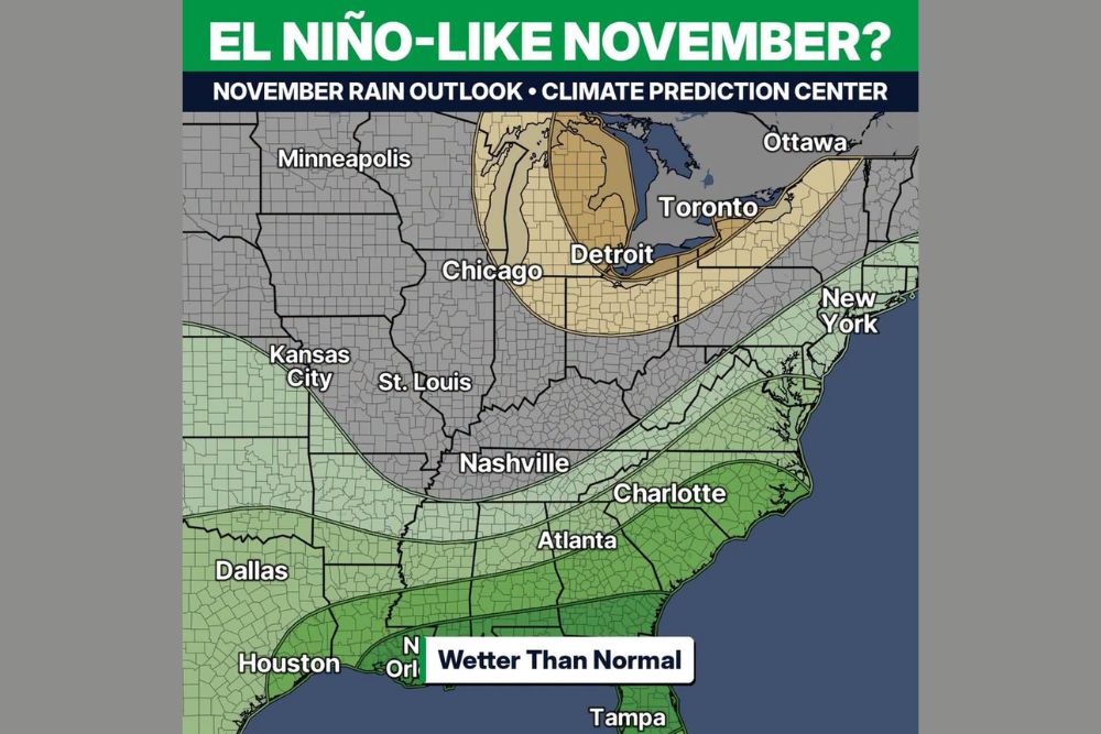
The strongest odds for wetter than normal conditions are centered along the Gulf Coast, including southern Louisiana, Mississippi, Alabama, Georgia, and north and central Florida. Cities such as New Orleans and Tampa fall within the deepest green shading on the outlook map, indicating the highest confidence in above-normal rainfall.
Houston and southeast Texas also sit within this wetter zone, while Dallas falls along its northern edge.
Wetter Odds Extend to the Carolinas and East Coast
The wetter signal spreads northeastward across Atlanta, Charlotte, and much of South Carolina and North Carolina. A lighter leaning wet zone extends even farther north along the Appalachians and the East Coast, reaching Virginia, Maryland, New Jersey, and areas near New York.
Nashville and portions of Tennessee sit near the northern edge of the wetter zone, with lower confidence than areas farther south.
Drier Signal Around the Great Lakes
Not every region is expected to turn wetter. A drier than normal zone is highlighted across Michigan, northern Ohio, northern Indiana, and parts of Pennsylvania and western New York, extending toward Toronto and Ottawa in Canada. Detroit falls within this drier area, while Chicago sits near its western edge.
Much of the Midwest and Plains, including Minneapolis, Kansas City, and St. Louis, shows equal chances, meaning no strong tilt toward wetter or drier conditions.
Why El Niño Favors a Wet Southeast
During El Niño, warmer than normal waters in the equatorial Pacific Ocean help strengthen the subtropical jet stream. This jet often dips farther south across the United States, steering repeated storm systems from Texas across the Gulf states and into the Southeast.
That pattern typically brings more frequent rain events, cloudier skies, and cooler daytime temperatures to the region during the cool season.
Welcome Relief After a Dry October
A wetter November would be a significant shift after an extended dry stretch that has worsened drought conditions, raised fire danger, and stressed lawns, gardens, and farmland across the Southeast. Repeated rounds of rain could help replenish soil moisture and recharge ponds, lakes, and water supplies.
However, heavy rain falling on hardened, dry ground can run off quickly, so localized flooding remains possible during stronger events.
Outlooks Show Odds, Not Guarantees
Monthly outlooks indicate probabilities, not exact forecasts. Dry stretches may still occur between storms, and rainfall totals will depend on the track and strength of individual systems.
For continuing coverage of November outlooks, El Niño updates, and critical weather analysis across the United States, visit Weather Radar.