Florida Sea Level Swung 480 Feet Over 500,000 Years as Ice Ages Flooded Half the State Then Pushed the Shore Far West of Tampa
TAMPA, FL — Florida’s shoreline has changed dramatically over the past 500,000 years, with sea levels swinging by roughly 480 feet as Earth moved in and out of ice ages. At times, rising oceans covered nearly half of the state, while during colder periods the coastline stretched so far out that reaching the beach from Tampa would have required walking about 130 miles west. These natural cycles help explain why Florida’s bedrock is made largely of limestone and why much of the state was once a shallow sea and coral reef.
Earth’s Orbit Drives the Ice Age Cycle
Roughly every 100,000 years, Earth goes through natural cycles of glaciation and warming. These cycles are driven by gradual changes in Earth’s orbit and the tilt of its axis, which alter how much sunlight different parts of the planet receive over long periods.
When less sunlight reaches the high latitudes, massive ice sheets grow and lock up enormous amounts of water, lowering global sea levels. When the ice melts during warmer periods, that water flows back into the oceans, raising sea levels significantly.
When Half of Florida Was Underwater
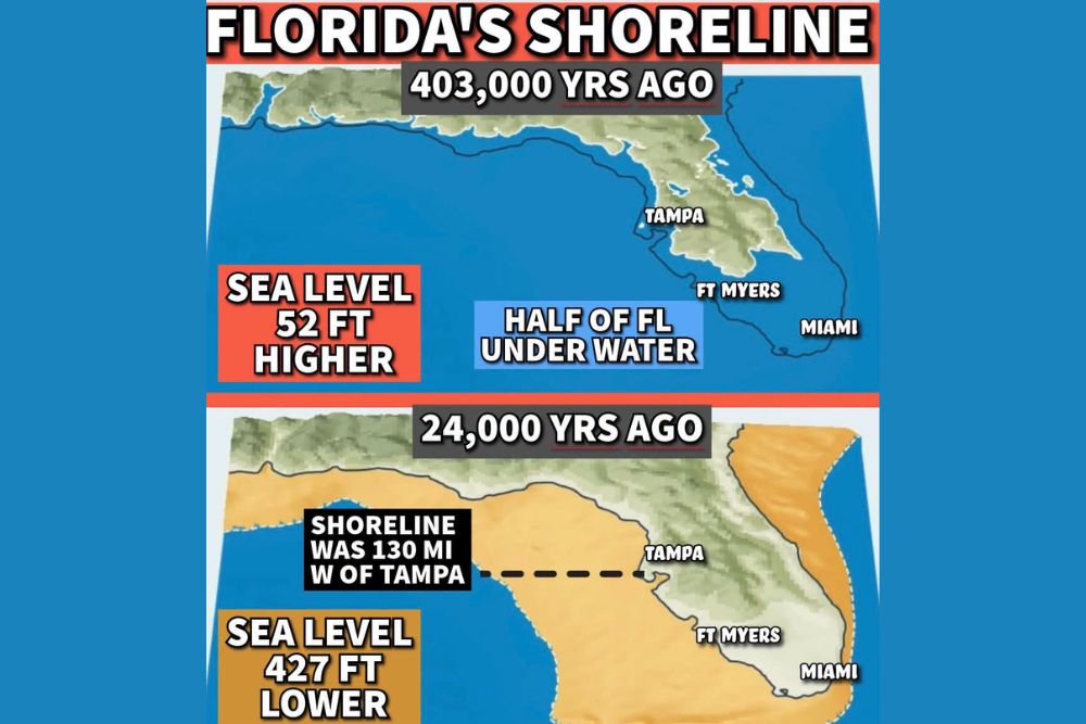
About 403,000 years ago, during a warm period when large portions of the polar ice caps melted, global sea levels rose to roughly 52 feet higher than today. At that level, much of Florida was submerged beneath the ocean.
Maps of this period show only the northern and central spine of the state above water, with large portions of South Florida, including areas near Fort Myers and Miami, lying beneath the sea. Coastal areas around Tampa were also much farther inland than today.
When Florida Was Twice Its Size
The opposite happened about 24,000 years ago, during the peak of the last ice age. With vast amounts of water trapped in miles of ice across North America and Europe, sea levels dropped to about 427 feet lower than today.
During this time, Florida was roughly twice its current size. The Gulf Coast shoreline extended about 130 miles west of Tampa Bay, and land also stretched farther east into the Atlantic. Much of the continental shelf that is underwater today was exposed as dry land.
Why Florida Is Built on Limestone
These repeated cycles of flooding and exposure shaped Florida’s geology. During long periods underwater, shells, coral, and marine organisms accumulated on the seafloor. Over time, these deposits hardened into limestone, which now forms the foundation beneath much of the state.
This limestone base also explains Florida’s sinkholes, springs, and vast underground aquifer system.
Lessons for Today
Understanding these natural changes provides valuable context for how sensitive Florida’s low-lying landscape is to changes in sea level. Even small changes can significantly affect coastal communities.
For continuing coverage of Florida weather, climate history, and critical weather analysis across the United States, visit Weather Radar.