Extreme Rain Could Dump Up to 12 Inches Near Globe, Arizona as the Mogollon Rim Faces Major Flooding and Show Low Projections Top 5 Inches
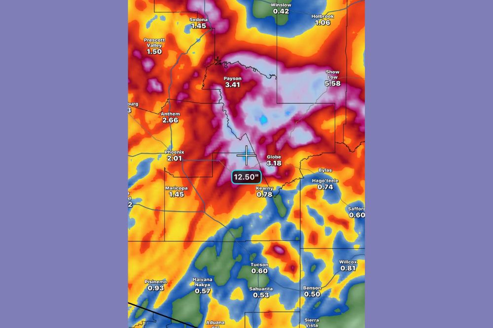
GLOBE, AZ — Parts of Arizona could see extreme rainfall totals over the next 48 hours, with most of the rain expected on Sunday, November 1. The Saturday evening HRRR model shows as much as 12.5 inches of rain just west of Globe, an extraordinary amount for the desert Southwest. Even a blended model, which averages many forecast outputs, shows about 9 inches in that same area. The Mogollon Rim is expected to be hit hardest, with major flooding likely across central and eastern Arizona.
Heaviest Rain Over Central Arizona
The most intense rainfall on the model map is focused across the high terrain between Payson, Globe, and Show Low. A large area shaded in purple and light blue indicates totals well above 4 to 6 inches, with the peak near 12.50 inches west of Globe in the Tonto National Forest.
Show Low is projected near 5.58 inches, while Payson sits around 3.41 inches and Globe near 3.18 inches.
Phoenix and Surrounding Areas Also Soaked
The Phoenix metro area could also see significant rainfall. Anthem is projected near 2.66 inches, Phoenix around 2.01 inches, and Maricopa about 1.45 inches.
Farther north, Sedona shows about 1.45 inches, Prescott Valley around 1.50 inches, and areas near Flagstaff close to 2.46 inches.
Lighter Totals in Southern and Northeastern Arizona
Southern Arizona will see lighter but still notable rainfall. Tucson is projected near 0.60 inches, Sahuarita around 0.53 inches, Benson near 0.50 inches, and Willcox about 0.81 inches. Safford shows around 0.60 inches.
In northeastern Arizona, Holbrook is projected near 1.06 inches, while Winslow sees about 0.42 inches.
Major Flooding Concerns
Rainfall of this magnitude could cause severe flash flooding in canyons, washes, and creeks across the Mogollon Rim and Tonto National Forest. Rivers such as the Salt River, Verde River, and Tonto Creek may rise rapidly, threatening low-water crossings and nearby communities.
Burn scars from past wildfires are especially vulnerable to debris flows and mudslides during heavy rain.
Impacts Could Reach Colorado
Moisture from this storm system is also expected to move into the San Juan Mountains of southwest Colorado, where heavy snow and rain could renew flooding concerns after record rainfall and river flooding earlier in October.
Turn Around, Don’t Drown
Residents should never drive through flooded roads or washes. Water can rise within minutes, and moving water can easily sweep vehicles away.
For continuing coverage of Arizona flooding, Southwest storms, and critical weather analysis across the United States, visit Weather Radar.