Weak Low Near the Bahamas Drives Atlantic Wind Gusts Over 30 MPH Into East Florida Tuesday as Coastal Flooding Worsens During High Tide Cycles
WEST PALM BEACH, FL — A weak area of low pressure lingering near the Bahamas is sending gusty winds in from the Atlantic Ocean across eastern Florida on Tuesday, October 27. Wind gusts of 30 mph or more are expected along much of the east coast, with the strongest gusts near the Treasure Coast and Southeast Florida. The persistent onshore winds are also expected to cause more coastal flooding, especially during high tide cycles, as king tides continue to affect the state.
Strongest Gusts Along the Southeast Coast
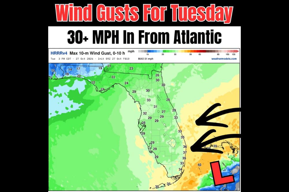
The HRRR model forecast for maximum wind gusts through 3 PM EDT Tuesday shows the strongest winds focused along the Atlantic coastline. Gusts are expected to reach around 36 to 37 mph near the Treasure Coast, including areas near Stuart and Jupiter, while gusts near West Palm Beach reach about 35 mph.
Farther south, gusts of around 33 to 34 mph are expected near Fort Lauderdale and Miami, while the Florida Keys could see gusts near 35 mph. Offshore, wind gusts may exceed 40 mph closer to the low pressure system, with the model showing a maximum of around 51 mph over the water.
Breezy Conditions Along the Space Coast and Northeast Florida
Along the Space Coast, gusts of around 33 to 35 mph are forecast near Melbourne and Vero Beach. Farther north, gusts near Daytona Beach and St. Augustine will reach about 26 to 30 mph, while Jacksonville sees gusts near 26 to 30 mph.
These winds will create choppy seas, rough surf, and dangerous rip currents along Atlantic beaches throughout the day.
Interior and Gulf Coast See Lighter Winds
Winds will be somewhat lighter across the Florida interior and Gulf Coast, though still breezy at times. Orlando and Central Florida may see gusts around 27 to 31 mph, while the Tampa Bay area and Southwest Florida see gusts near 28 to 32 mph.
The Florida Panhandle will experience the lightest winds, with gusts mostly between 19 and 24 mph near Pensacola, Panama City, and Tallahassee.
Coastal Flooding Continues With King Tides
The onshore wind flow will push additional water toward the coast, increasing the risk of coastal flooding during high tide. This comes on top of exceptionally high king tides that have already caused saltwater flooding in vulnerable neighborhoods along Florida’s Atlantic coast.
Low-lying streets, parking lots, and properties near the Intracoastal Waterway, bays, and canals are most at risk. Residents should check local tide schedules and avoid driving through flooded roads, as saltwater can cause serious damage to vehicles.
Marine and Beach Hazards
Boaters should use caution due to rough seas and gusty winds, while beachgoers should stay out of the water if lifeguards fly warning flags. Beach erosion may also continue along exposed shorelines.
Watching the Low Near the Bahamas
Forecasters will continue monitoring the weak low near the Bahamas, though its main impact on Florida remains wind and coastal flooding.
For continuing coverage of Florida coastal flooding, wind alerts, and critical weather analysis across the United States, visit Weather Radar.