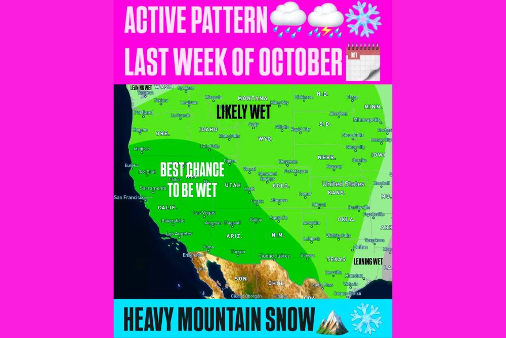
Wet Pattern and Heavy Mountain Snow Target California, Nevada, Utah and Colorado Late October as Rain Chances Spread to Texas, Oklahoma, Kansas
DENVER, CO — Confidence is growing in a much wetter pattern across large portions of the western United States and the Great Plains during the final week of October, with the active setup potentially continuing into early November. A persistent trough near the West Coast is expected to steer repeated rounds of Pacific moisture inland, bringing lower elevation rain and heavy mountain snow from California and the Pacific Northwest into the Great Basin and Rockies.
Best Chance for Wet Weather Centered on the West
The outlook places the best chance for wet conditions across California, Nevada, Utah, Arizona, Colorado, and New Mexico. Cities within this zone include Sacramento, San Francisco, Bakersfield, Los Angeles, Las Vegas, Fallon, Ely, Moab, Flagstaff, Tucson, Santa Fe, and Alamosa.
This region could see multiple systems move through over the course of the week, with breaks in between. After a long and dry summer and early fall in many of these areas, the change would mark a significant shift toward a more active cool season pattern.
Likely Wet Conditions Across the Northern and Central States
Beyond the core zone, a broad area is rated likely wet, covering Oregon, Idaho, Montana, Wyoming, North Dakota, South Dakota, Nebraska, Kansas, Oklahoma, and much of Texas. Cities such as Portland, Boise area communities, Missoula, Cheyenne, Rapid City, Omaha, Kearney, Amarillo, Lubbock, and Wichita Falls fall within this region.
Areas on the outer edges, including western Washington near Tacoma, as well as eastern Texas near Dallas and Houston, sit in the leaning wet category, indicating slightly lower confidence but still a tilt toward above normal precipitation.
Heavy Mountain Snow Possible in the Rockies
Cooler air settling across parts of the West could support accumulating snow in the higher terrain wherever moisture and cold air overlap. The Sierra Nevada, Wasatch Range, Colorado Rockies, and mountain ranges across Idaho, Montana, and Wyoming are among the areas that could see heavy mountain snow.
Early season snowfall would be welcome news for ski resorts and long-term water supplies, but it could also create travel difficulties on mountain passes. Drivers planning trips through high elevation routes should be prepared for winter driving conditions and possible chain requirements.
Wetter Signal Extends Across the Plains
As storm systems move eastward out of the Rockies, the wetter signal also extends into the northern, central, and southern Plains. Texas, Oklahoma, and Kansas are among the states that could benefit from above normal precipitation, which may help ease dryness across parts of the region.
Forecast guidance currently favors above normal precipitation across this broad area, with above average confidence in the overall pattern. However, rainfall amounts will vary widely depending on the track and strength of each system.
Timing and Totals Remain Uncertain
While the overall pattern appears increasingly likely, exact storm timing, snow levels, and precipitation totals remain uncertain. There will also be quieter breaks between systems, meaning not every day of the final week of October will be wet.
Residents across the West and Plains should monitor forecasts closely as the end of the month approaches, especially those with travel plans, outdoor events, or agricultural activities scheduled during the period.
For continuing coverage of storm patterns, mountain snow forecasts, and critical weather analysis across the United States, visit Weather Radar.