Warm 70s Streak Rolls On Across Northern Illinois and Southern Wisconsin as Rockford Nears 75 Degrees Sunday With Rain Held Off Until Tuesday
ROCKFORD, IL — An impressive stretch of warm fall weather shows no signs of ending across Northern Illinois and Southern Wisconsin. The region has now recorded three straight days with temperatures at or above 70 degrees, and that streak is set to continue through the weekend. Even warmer temperatures are on the way to close out the workweek, with highs climbing into the mid 70s by Sunday, while rain stays out of the forecast until at least next Tuesday.
Warmer Temperatures to Close Out the Week
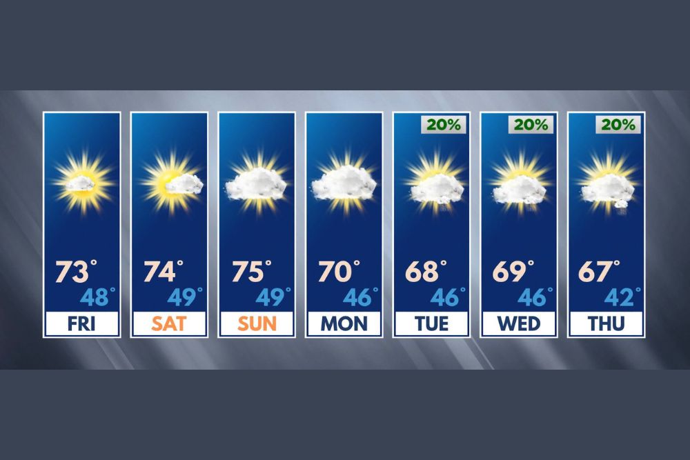
The extended forecast for October 23 through 29 shows the warmth building heading into the weekend. Friday is expected to reach about 73 degrees, following a morning low near 48 degrees. Saturday climbs slightly higher to around 74 degrees with a low near 49 degrees.
Sunday is forecast to be the warmest day of the stretch, with highs reaching about 75 degrees after a morning low near 49 degrees. These readings are well above normal for late October in the Stateline area, offering a rare extended taste of mild weather this late in the season.
Increasing Clouds but No Rain Through Monday
While sunshine will remain dominant, each day between now and Monday will bring a bit more cloud cover. Even so, the added clouds are not expected to bring any rainfall or affect outdoor plans across the region.
Monday will see highs near 70 degrees with a low of about 46 degrees under partly to mostly cloudy skies. Despite the cooler reading, the day will still be pleasant and dry, extending the streak of 70-degree days into the new week.
Small Rain Chances Return Next Week
The first chance of rain in the extended outlook arrives on Tuesday, though chances remain minimal at about 20 percent. Highs on Tuesday will dip slightly to around 68 degrees, with a morning low near 46 degrees.
Wednesday carries another 20 percent rain chance with highs near 69 degrees, while Thursday also holds a 20 percent chance with cooler temperatures, as highs reach about 67 degrees and lows fall to around 42 degrees. Any rainfall during this period is expected to be light and scattered.
A Gradual Cooling Trend Ahead
After the weekend peak, temperatures will slowly trend downward through the middle of next week. Even so, highs in the upper 60s remain above average for late October, and nights will stay mild compared to typical fall conditions in Northern Illinois and Southern Wisconsin.
The cooler morning low of 42 degrees on Thursday hints at a gradual return to more seasonal weather as the calendar approaches November.
Perfect Timing for Weekend Plans
With dry skies and warm temperatures, the weekend offers excellent conditions for fall festivals, pumpkin patches, apple orchards, high school football, and outdoor yard work. Residents can also take advantage of the mild weather to complete seasonal chores before colder conditions arrive.
Enjoy the Extended Warmth
Late October warmth like this is uncommon across the region, and residents are encouraged to make the most of it. Forecasters will continue monitoring next week’s rain chances, though any significant changes to the dry pattern appear unlikely in the near term.
For continuing coverage of Midwest forecasts, fall weather updates, and critical weather analysis across the United States, visit Weather Radar.