Very Strong El Niño Raises Odds of a Wetter Stormier Winter Across Alabama With Heavy Rain and Flooding Risks as Arctic Cold Remains Possible
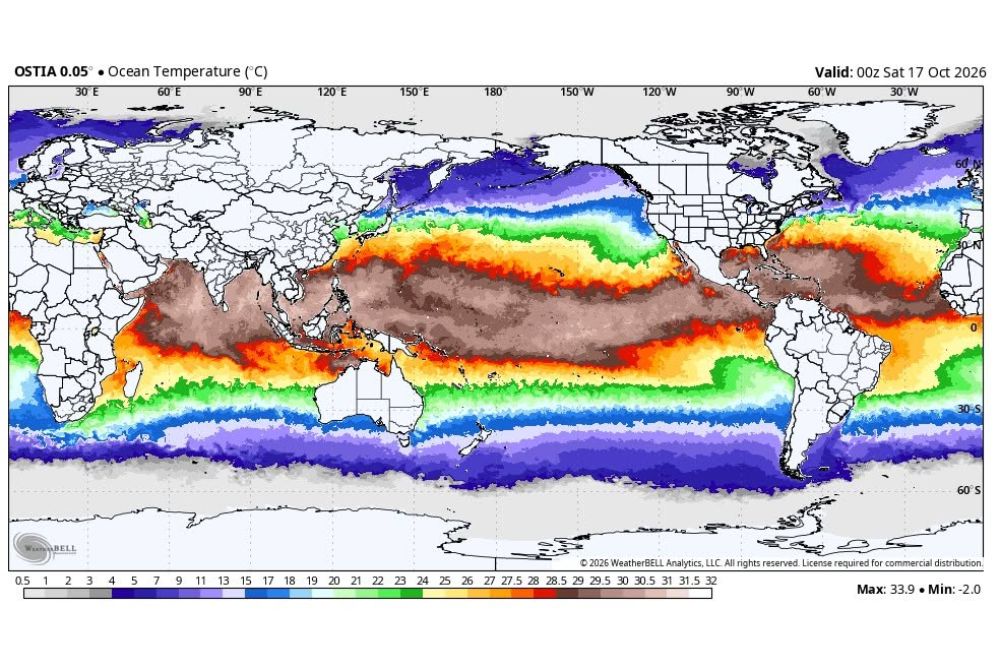
BIRMINGHAM, AL — A very strong El Niño continues to evolve across the Pacific Ocean, and its influence could shape the upcoming winter season across Alabama and the Deep South. Ocean temperature analysis valid Saturday, October 17, 2026, shows a broad band of exceptionally warm water stretching along the equatorial Pacific, a signature pattern that often tilts the odds toward a wetter and stormier winter for the southern United States.
Understanding El Niño and the Super El Niño Label
El Niño is a natural climate pattern marked by warmer than average sea surface temperatures across the central and eastern equatorial Pacific. When these ocean temperatures rise sharply, the pattern can alter the position and strength of the jet stream, which in turn influences weather across North America for months at a time.
A Super El Niño is an informal term generally used when sea surface temperatures in a key monitoring region of the Pacific reach at least 2 degrees Celsius above average. While not an official classification, the label is commonly applied to the strongest events on record, which tend to produce the most noticeable seasonal impacts.
Ocean Data Shows Widespread Pacific Warmth
The latest ocean temperature map highlights a wide corridor of warm water spanning from the western Pacific across the equator toward South America. Peak readings on the analysis reach as high as 33.9 degrees Celsius, while the coldest waters near the polar regions fall to around minus 2 degrees Celsius.
The deep warmth along the equator is the key feature forecasters watch when tracking the strength and evolution of El Niño. Its persistence into late fall suggests the pattern will remain a major factor heading into the winter months.
Wetter Winter Is the Primary Concern for Alabama
The strongest and most consistent link between El Niño and Alabama weather is precipitation. El Niño typically favors a more active southern storm track, increasing the odds of a wetter than average winter across the Deep South. This could bring more frequent opportunities for heavy rain and localized flooding across the state.
Residents in flood-prone areas, low-lying communities, and locations near rivers and creeks should stay alert as the season unfolds, since repeated rounds of rainfall can saturate soils and raise flood risks quickly.
Severe Weather Season Remains Uncertain
Severe thunderstorms and tornadoes are always a concern in Alabama, but El Niño alone cannot determine how active the coming severe weather season will be. The Alabama tornado season runs from November through May, and the previous season was remarkably quiet.
Forecasters doubt the upcoming season will remain as calm. An active storm track may increase opportunities for strong systems, though the setup of each individual event will ultimately determine whether severe weather develops.
Cold Air and Winter Weather Still Possible
A strong El Niño does not mean Alabama will escape cold weather. Arctic air can still push into the state at times, and sharp temperature swings remain possible throughout the winter season.
Snow and ice remain difficult to predict far in advance. A stormier pattern does not automatically translate into more winter precipitation, since the temperature profile and track of each storm will determine whether rain, sleet, freezing rain, or snow falls.
The Bottom Line for the Winter Ahead
A wetter and stormier winter stands as the most likely impact for Alabama, but seasonal climate patterns do not guarantee specific weather events. El Niño shifts the odds without dictating day-to-day conditions, making regular forecast updates essential as winter approaches.
For continuing coverage of El Niño developments, seasonal outlooks, and critical weather analysis across the United States, visit Weather Radar.