Severe Storms Could Bring a Couple of Tornadoes, Large Hail and Damaging Winds to Oklahoma and North Texas Monday Afternoon From Enid to Abilene
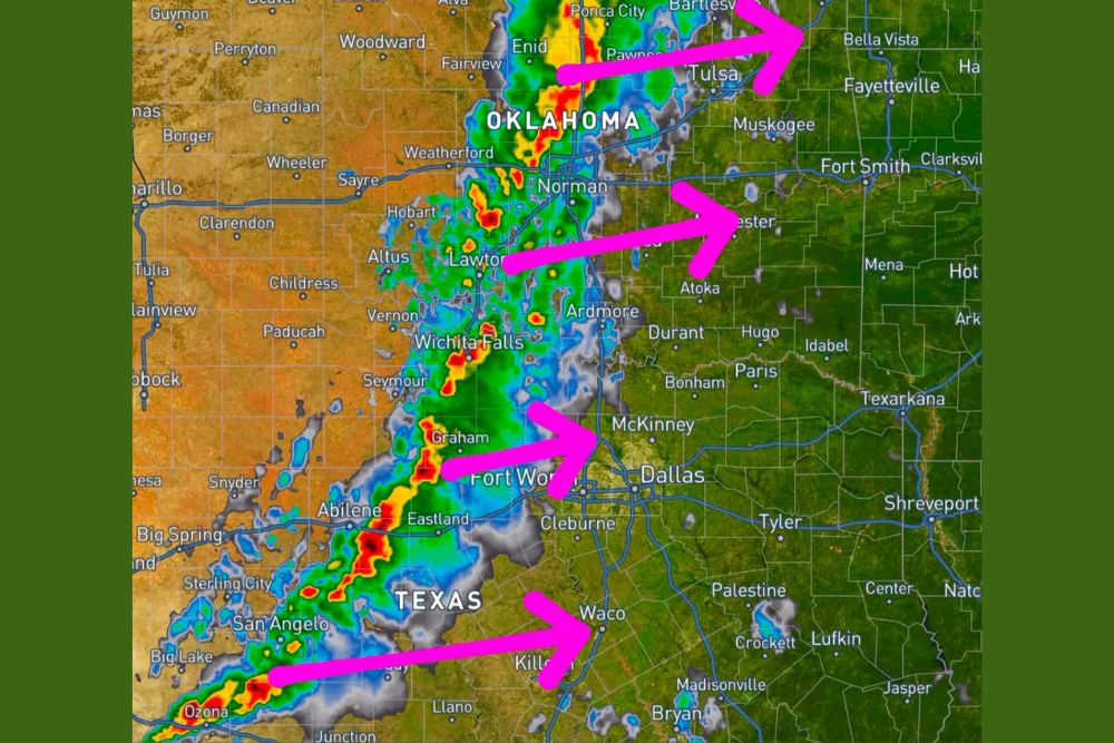
OKLAHOMA CITY, OK — Monday afternoon and evening, November 2, are now coming into range of high-resolution forecast guidance, giving an early look at how severe storms could develop across Oklahoma and North Texas. One model shows a line of strong thunderstorms forming by late Monday afternoon from northern Oklahoma southwest into West Central Texas. All modes of severe weather are possible, including a couple of tornadoes, large hail, and damaging winds. While timing and storm coverage still need refinement, this is a setup worth watching closely.
Line of Storms From Enid to Ozona
The model guidance shows a long line of thunderstorms stretching from near Enid and Ponca City in northern Oklahoma southwest through Norman, Lawton, and Wichita Falls. The line continues into Texas, passing near Graham, Abilene, San Angelo, and Ozona.
Several individual storm cells within the line show intense red and orange radar returns, suggesting strong updrafts capable of producing hail and damaging winds. Some of the strongest cells appear near Graham, Abilene, and areas west of Lawton.
Storms Moving East Toward Major Cities
The storms are expected to move east through the evening, potentially reaching Tulsa, McAlester, the Dallas-Fort Worth Metroplex, and Waco. Communities such as McKinney, Cleburne, Ardmore, Durant, and Killeen may also be in the path of storms later Monday evening.
Storms could eventually push toward Fort Smith, Fayetteville, and Bella Vista in Arkansas later in the night.
Tornado Threat Possible
Forecasters say a couple of tornadoes are possible with the strongest storms, especially any that remain separate from the main line or form ahead of it. Strong wind shear associated with the approaching storm system could help storms rotate.
Tornadoes in fall can be fast-moving and may occur after dark, making it important for residents to have multiple ways to receive weather alerts.
Large Hail and Damaging Winds
Large hail may accompany the strongest storms, capable of damaging vehicles, roofs, and windows. As storms merge into a line later in the evening, damaging wind gusts may become the primary threat, potentially knocking down trees and power lines.
Part of a Larger Storm System
This severe weather threat is tied to a strong storm system moving out of the Rockies and into the Plains, which is also bringing heavy mountain snow to Colorado and a deep drop in barometric pressure across the central United States. A strong cold front behind the system will bring much cooler air to Texas and Oklahoma later in the week.
Prepare Now
Residents should review severe weather plans, make sure phones can receive emergency alerts, and identify a safe shelter location before Monday afternoon.
For continuing coverage of Oklahoma and Texas severe storms, tornado alerts, and critical weather analysis across the United States, visit Weather Radar.