Powerful Storm Brings Heavy Rain, Flooding and an Overnight Tornado Risk to Los Angeles, Orange, Ventura and Santa Barbara Counties in California
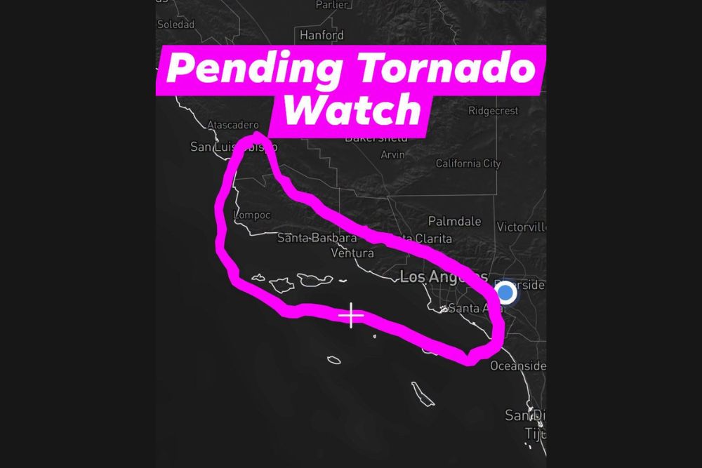
LOS ANGELES, CA — A powerful storm system dropping south from the Gulf of Alaska is set to bring heavy rain, flooding concerns, and a possible overnight severe weather threat to Southern California from Wednesday into Thursday. The area of greatest concern stretches along the coast from San Luis Obispo County through Santa Barbara, Ventura, Los Angeles, and Orange counties, where the combination of cold air aloft and strong wind shear could support rotating thunderstorms and a few brief tornadoes overnight.
Two Rounds of Wet Weather Expected
The storm is expected to arrive in two distinct rounds. The first round will move through during the day on Wednesday, driven by a warm conveyor belt of moisture streaming into the region ahead of the main system. This round will bring steady, moderate to heavy rain across coastal and valley communities.
The second round arrives overnight Wednesday into Thursday morning, when colder air aloft moves over the region. This colder air will increase atmospheric instability, allowing stronger thunderstorms to develop along and near the coast.
Overnight Storms Could Produce Rotation
The overnight round is the main concern for severe weather. The combination of cold air aloft and strong wind shear can help storms rotate, raising the potential for isolated tornadoes, waterspouts along the coastline, small hail, and gusty winds. Tornadoes in Southern California are typically brief and weak, but they can still cause localized damage and are especially dangerous at night when they are harder to see.
Any official tornado watch would be issued by the Storm Prediction Center, while warnings for individual storms come from the National Weather Service. Residents should rely on these official sources for alerts as the night unfolds.
Area of Concern Along the Coast
The highlighted risk zone covers coastal and near-coastal areas from San Luis Obispo and Lompoc south through Santa Barbara, Ventura, Santa Clarita, Los Angeles, and Santa Ana. The zone also extends over the coastal waters surrounding the Channel Islands.
Areas farther inland, such as Palmdale, Victorville, and Bakersfield, appear to fall outside the main severe weather zone, though rain and gusty winds remain possible across the broader region.
Flooding and Debris Flow Concerns
Heavy rain from both rounds could lead to urban flooding, overflowing storm drains, and water ponding on freeways and surface streets. Communities near recent burn scars face an elevated risk of mudslides and debris flows, as burned soil cannot absorb water effectively.
Residents in canyon areas and foothill neighborhoods should monitor local alerts closely and be ready to act quickly if evacuation orders are issued.
Safety Tips for Overnight Storms
Because the strongest storms may arrive while many people are asleep, residents should make sure phones are set to receive Wireless Emergency Alerts. If a tornado warning is issued, move to an interior room on the lowest floor and stay away from windows. Drivers should avoid flooded roads, as even shallow moving water can sweep away vehicles.
Conditions Improve Later Thursday
The storm is expected to move east by later Thursday, allowing conditions to gradually improve across Southern California. Forecasts will continue to be updated as the system approaches.
For continuing coverage of California storms, tornado alerts, and critical weather analysis across the United States, visit Weather Radar.