Polar Vortex Wildcard Could Reshape a Mild El Niño Winter for Minnesota, Wisconsin, Iowa and Michigan as Big Storms Favor Areas South of I-90
MINNEAPOLIS, MN — The polar vortex is shaping up to be one of the biggest wildcards heading into winter 2026 to 2027, and its behavior could determine whether the Upper Midwest sees a mild season or something much more severe. An updated unofficial winter outlook favors temperatures averaging 3 to 5 degrees above normal across the Upper Midwest from December through February, with near-normal to slightly below-normal readings farther south. However, a possible weakening of the polar vortex during November could dramatically change that picture heading into December and beyond.
Polar Vortex Could Flip the Script
The polar vortex is a large area of cold air that circulates high above the Arctic. When it is strong and stable, frigid air tends to stay locked near the North Pole. When it weakens or becomes disrupted, that cold air can spill southward into the United States.
A weakening of the polar vortex is expected to become a major factor throughout November. If a Sudden Stratospheric Warming event develops, it could disrupt the vortex and send bitter cold air into the central and eastern U.S., potentially overriding the typical mild influence of El Niño.
Warmest Signal Across the Upper Midwest
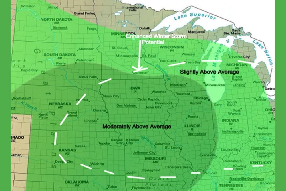
The outlook places the moderately above average temperature zone across North Dakota, South Dakota, Minnesota, Wisconsin, northern Iowa, northern Illinois, and much of Michigan. Cities such as Fargo, Minneapolis, St. Paul, Madison, Milwaukee, Green Bay, Chicago, Grand Rapids, and Detroit fall within this warmer zone.
A slightly above average zone stretches across Nebraska, southern Iowa, central Illinois, Indiana, Ohio, and Kentucky, while a slightly below average zone extends across Colorado, Kansas, and southern Missouri.
Active Storm Track Along and South of I-90
An exceptionally active pattern, driven by interactions between the polar jet stream and the subtropical jet stream, could significantly increase winter storm opportunities along and south of Interstate 90. The outlook highlights moderately above average precipitation across Nebraska, Iowa, Kansas, Missouri, and Illinois, including areas near Des Moines, Omaha, Kansas City, and St. Louis.
Slightly above average precipitation is favored across Minnesota, Wisconsin, Michigan, and Indiana, with an enhanced winter storm potential area noted near Rochester and southern Minnesota.
Late Winter Could Bring the Biggest Storms
The period from January 15 through early spring appears especially favorable for potentially large winter storms. Storms forming near the southern edge of persistent ridging could bring heavy snow and ice to parts of the Midwest and Plains, though exact storm tracks remain uncertain this far in advance.
Strong El Niño Winters and Warm Decembers
Historically, strong El Niño winters have often featured exceptionally warm Decembers across the northern United States. If the polar vortex remains stable, that pattern could repeat. But a major disruption could bring sharp cold outbreaks instead.
An Outlook, Not a Guarantee
This is an early, unofficial seasonal outlook and may change significantly as winter approaches. Residents should follow official forecasts for updates.
For continuing coverage of winter outlooks, polar vortex updates, and critical weather analysis across the United States, visit Weather Radar.