Long Dry Spell Ends Across Alabama This Weekend With Widespread Sunday Rain as Strong Storms Become Possible Midweek When Tornado Season Begins
BIRMINGHAM, AL — A major pattern change is on the way for Alabama, as the long dry spell that has gripped the state for weeks is expected to end this weekend. The highest coverage of rain is forecast for Sunday, November 1, bringing much-needed relief to drought-stricken areas. A more dynamic storm system is then expected by the middle of next week, which could bring the potential for strong to severe thunderstorms. The timing is notable, as Alabama’s tornado season officially begins on Sunday and runs from November through May.
Weekend Rain Brings Drought Relief
After an extended stretch of sunny and dry weather, rain chances will increase across Alabama over the weekend. Showers may begin as early as Saturday, but the most widespread rainfall is expected on Sunday, when the greatest coverage of rain will spread across much of the state.
This rain will be a welcome sight for farmers, gardeners, and homeowners dealing with dry lawns, stressed vegetation, and elevated fire danger. While one system will not erase the drought, it marks the beginning of a wetter pattern.
Deep Upper-Level Trough Arrives Midweek
The ECMWF upper air pattern for Wednesday night, November 4, shows a deep trough in the jet stream digging into the central United States. This dip in the jet extends from the Upper Midwest through the Mississippi Valley and into the Gulf Coast region.
Systems like this often bring stronger dynamics, cooler air behind them, and the potential for organized thunderstorms ahead of the associated cold front.
Instability Builds Across the Deep South
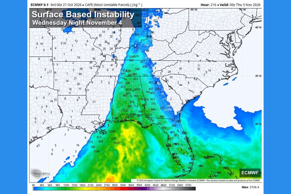
Model guidance for surface-based instability shows a corridor of higher CAPE values stretching northward from the Gulf of Mexico into Mississippi, Alabama, and parts of Tennessee. Values exceeding 1,000 J/kg appear across portions of Alabama, with even higher values near the Gulf Coast and over the water.
CAPE, or Convective Available Potential Energy, measures how much energy is available for thunderstorms to grow. Higher values can support stronger storms when combined with wind shear and a triggering mechanism like a cold front.
Too Early for Specifics
Forecasters emphasize that it is too early to determine the exact timing, location, or severity of any storms. The setup is simply something to watch over the coming days as forecast models come into better agreement.
Alabama Tornado Season Begins Sunday
Alabama experiences two peaks in tornado activity, with a secondary season beginning in November and continuing through the spring. Late-fall storms can be dangerous because they often occur at night and move quickly.
Residents should review severe weather plans, make sure weather alerts are enabled on their phones, and have a safe shelter location identified.
A More Active Pattern Ahead
The transition from a dry October to an active November signals a significant shift for Alabama and the Southeast.
For continuing coverage of Alabama rain chances, severe weather outlooks, and critical weather analysis across the United States, visit Weather Radar.