Cold 40s Mornings and Sunny 70s Afternoons Grip Birmingham, Alabama as Dry Weather Deepens Drought and Rain May Not Return Until November
BIRMINGHAM, AL — Another cold start greeted Central Alabama this morning, but abundant sunshine is set to push afternoon highs close to 70 degrees, delivering one of the most comfortable fall days of the season so far. Winds are calmer than recent days, with a light east-northeast breeze of 5 to 10 mph keeping conditions pleasant from morning through the evening hours.
Chilly Air Returns by Tomorrow Morning
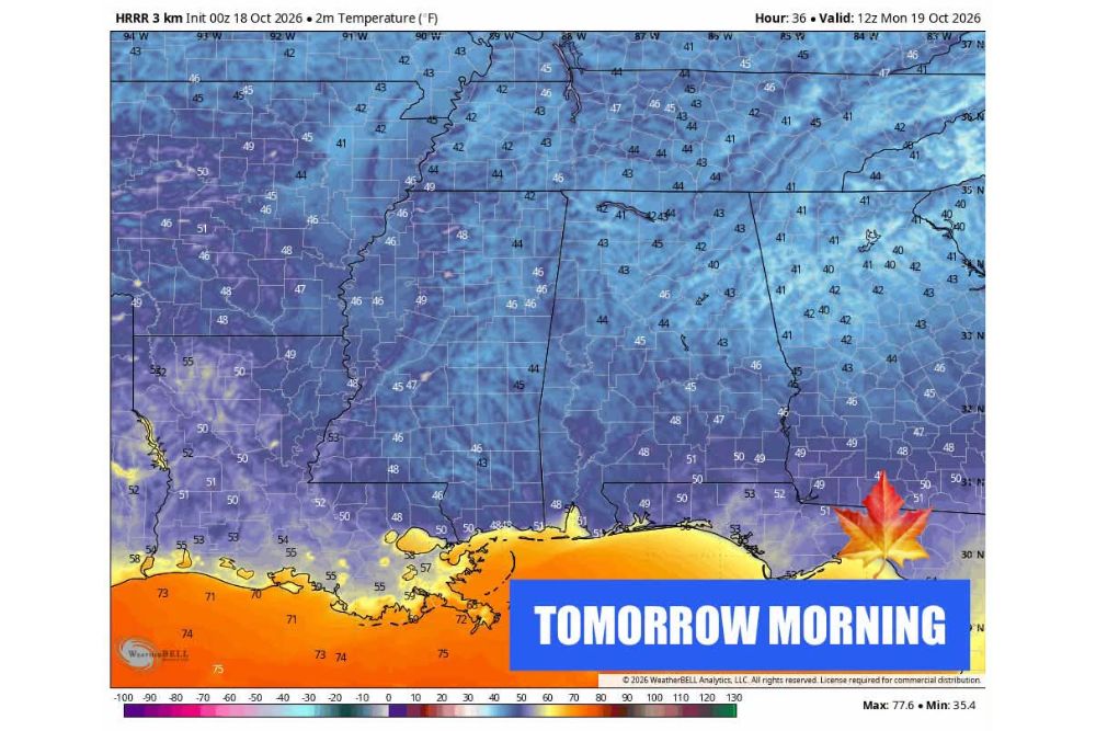
The same crisp pattern repeats overnight as clear skies and dry air allow temperatures to fall quickly after sunset. Forecast maps show widespread readings in the 40s across Alabama, Mississippi, Tennessee, and Georgia by tomorrow morning, with a few spots dipping into the upper 30s. Lows near 41 to 44 degrees are expected across much of North Alabama and North Georgia, while areas closer to the Gulf Coast stay milder in the 50s.
Residents heading out early should plan for a jacket, as the chill will linger until the sun climbs high enough to warm the dry air. By early afternoon, a quick rebound into the 70s is expected once again, creating a wide daily swing of nearly 30 degrees between morning lows and afternoon highs.
A Comfortable Week Ahead With a Gradual Warming Trend
The extended outlook keeps highs in the 70s for most of the week ahead. The first half of the week will feature the coldest mornings, with lows holding in the 40s. By the second half of the week, lows are expected to moderate into the upper 40s and low 50s as the air mass slowly modifies.
The temperature trend shows a steady climb through the period, with afternoon highs moving from around 69 and 70 degrees early on to 75, 77, and 78 degrees by midweek. Highs could reach the low 80s by the final week of October, but the stretch of 90-degree heat that lingered into the early fall appears to be finished for the year.
Worsening Drought Conditions Across the Region
The persistent dry pattern is the main weather concern for Alabama and surrounding states. With no meaningful rainfall in sight, drought conditions are expected to worsen over the coming weeks. Long-range precipitation guidance shows only light totals across much of the Southeast, with most areas seeing just a few hundredths to a quarter of an inch through the forecast period.
The next chance for any measurable rain in the long range may not arrive until the start of November. This extended dry spell raises concerns for lawns, gardens, agriculture, and local water supplies, and the combination of low humidity, dry vegetation, and occasional breezes may also raise fire danger across the region. Residents are encouraged to follow local burn guidance and avoid outdoor burning during this period.
Tropics Quiet for Alabama Despite East Coast System
In the tropics, forecasters are monitoring a low chance of development with a system moving up the East Coast. This feature poses no concern for Alabama or the inland Southeast, and its movement away from the region keeps any tropical impacts well offshore.
The Atlantic hurricane season officially continues through the end of November, making next month the final stretch of the season. While activity typically slows considerably by late fall, forecasters will continue watching the tropics closely for any changes.
What Residents Should Expect Going Forward
For now, Central Alabama can look forward to a classic fall stretch of chilly mornings, comfortable sunny afternoons, and light winds. The tradeoff is the absence of rainfall, which will continue to deepen dryness across the state and the broader Southeast until a pattern change finally arrives.
Residents should keep layered clothing handy for the cold morning commutes, stay mindful of fire weather risks, and conserve water where possible as the dry stretch continues. Forecast updates will be important to watch as the long-range outlook approaches early November and the next potential rainmaker comes into clearer view.
For continuing coverage of fall weather patterns, drought updates, and critical forecast analysis across the United States, visit Weather Radar.