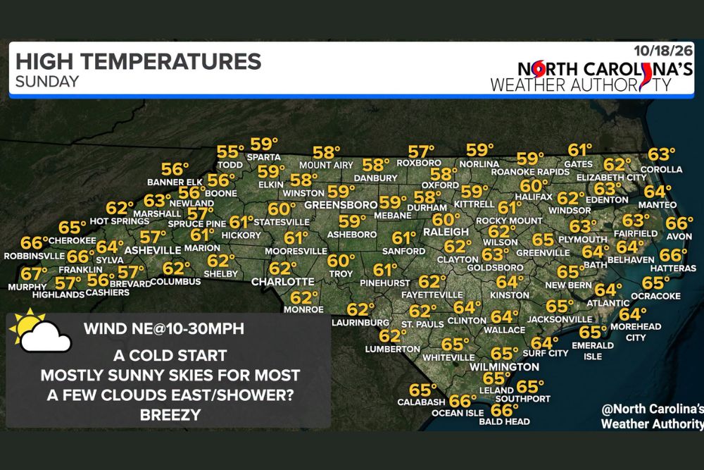
Breezy Winds and a Cold Start Give Way to Sunny 50s and 60s Across North Carolina as Outer Banks Showers Linger Along the Coast
RALEIGH, NC — A chilly start greeted communities across North Carolina on Sunday, October 18, but sunshine is returning to most of the state as the day progresses. Mostly sunny skies will dominate from the Mountains through the Piedmont, while a few clouds and a couple of passing showers remain possible along the coast, especially across the Outer Banks. Highs will climb into the 50s and 60s statewide, with a breezy northeast wind adding a crisp feel to the fall air.
Cold Morning Gives Way to Mild Afternoon Highs
After the cold start, temperatures will rebound into comfortable territory by the afternoon. Most of North Carolina will see highs ranging from the upper 50s to mid 60s, a pleasant range for mid October. The coolest readings will settle over the High Country and northern Piedmont, while the warmest air builds across the Coastal Plain and the southern coastline.
The combination of sunshine and a dry air mass across the interior will make for a bright day, though the steady breeze will keep the air feeling cooler than the thermometer suggests at times.
Mountains and Foothills Range From Mid 50s to Mid 60s
In the western part of the state, temperature ranges will vary with elevation. Boone and Banner Elk are expected to top out near 56 degrees, while Todd reaches about 55 degrees and Sparta climbs to around 59 degrees. Spruce Pine should reach about 57 degrees, with Newland near 63 degrees.
Lower valleys in the far southwest will run warmer. Asheville is forecast to reach around 64 degrees, with Cherokee and Robbinsville near 66 degrees and Murphy at about 67 degrees. Highlands and Cashiers will stay cooler at roughly 57 and 56 degrees, while Hickory reaches around 61 degrees.
Piedmont Cities Settle Into the Upper 50s and Low 60s
Across the Piedmont, highs will hover close to the 60-degree mark. Greensboro, Winston-Salem, and Durham are expected to reach about 59 degrees, while Mount Airy and Danbury stay near 58 degrees. Raleigh is forecast to reach around 60 degrees, with Statesville also near 60 degrees.
Farther south, Charlotte and Monroe should climb to about 62 degrees, while Mooresville reaches near 61 degrees. Pinehurst and Fayetteville are expected to see highs near 62 degrees, keeping conditions comfortable for outdoor plans across the Sandhills.
Coastal Areas Turn Breezy With Isolated Showers
The coast will be the breeziest part of the state, with northeast winds of 10 to 30 mph expected and the strongest gusts closest to the shoreline. Highs here will run in the mid 60s, including Wilmington, Leland, Southport, and Calabash near 65 degrees, with Ocean Isle and Bald Head around 66 degrees.
Along the Outer Banks, Avon and Hatteras are forecast near 66 degrees, while Manteo reaches about 64 degrees and Corolla near 63 degrees. Morehead City, Atlantic, and Ocracoke will sit in the 64 to 65 degree range. More clouds and a stray shower or two are possible across these barrier island communities, so beachgoers should keep an eye on the sky.
Eastern Interior Stays Mostly Sunny and Mild
Inland eastern towns will enjoy a mix of sun and a few clouds. Greenville and Kinston are expected to reach around 64 degrees, while New Bern and Jacksonville climb to about 64 and 65 degrees. Goldsboro and Clayton should top out near 63 and 62 degrees, and Rocky Mount reaches about 62 degrees.
What to Expect Through the Rest of the Day
Residents should dress in layers for the cool morning before temperatures warm through the afternoon. Boaters and anyone spending time along the coast should prepare for gusty conditions and choppy water, while the remainder of the state enjoys a bright and pleasant fall Sunday.
For continuing coverage of fall weather conditions, coastal forecasts, and critical weather analysis across the United States, visit Weather Radar.