Atlantic Low Gains 40% Development Odds as Coastal Flooding and High Surf Threaten Mid-Atlantic and Northeast While Florida Keeps Cool Dry Air
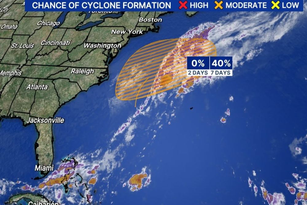
TAMPA, FL — The National Hurricane Center is monitoring a developing low pressure system in the western Atlantic Ocean that now carries a 40 percent chance of formation over the next 7 days. The system is forming along a stalled frontal boundary off the East Coast and is expected to drift very slowly toward the northeast later this week. Whether or not it earns a name, the storm is set to bring windy conditions, coastal flooding, and high surf to the Mid-Atlantic and Northeast coastlines for several days.
Development Chances Rise Later This Week
The latest Tropical Outlook shows a 0 percent chance of development over the next 2 days, rising to 40 percent over the next 7 days, placing the system in the moderate category. The outlined development area stretches offshore from the Carolinas and Virginia northeastward into the open Atlantic, well east of Washington, New York, and Boston.
The low is expected to organize gradually as it separates from the front. Its slow movement means it could linger off the coast for an extended period, prolonging impacts along the shoreline even if it never becomes a tropical or subtropical storm.
Subtropical Characteristics Possible
Forecasters say the system may develop subtropical characteristics, a hybrid structure that blends features of tropical storms and traditional coastal lows. Subtropical systems often have a broader wind field, with strong winds spread far from the center rather than concentrated around a tight core.
If the system meets the criteria, it could receive a name from the Atlantic hurricane season list. However, its classification will not change the main concern, as the storm is expected to remain a strong low pressure system capable of producing significant coastal impacts regardless of its label.
Coastal Impacts From the Mid-Atlantic to the Northeast
Communities along the Mid-Atlantic and Northeast coasts should prepare for several days of rough conditions. Gusty winds, dangerous rip currents, beach erosion, and coastal flooding are possible, especially during high tide cycles. Low-lying areas along barrier islands, bays, and inlets may see water pushed onto roads and properties.
High surf will also create hazardous conditions for swimmers and boaters. Residents in coastal areas from Virginia and Maryland to New Jersey, New York, and New England should monitor local forecasts and follow any coastal flood advisories or marine warnings.
Florida Benefits From Cooler and Drier Air
While Florida will not face direct impacts from the storm, the system will still influence weather across the Sunshine State. The counterclockwise spin of the low will help maintain a steady northeast flow across Florida throughout the week.
That wind pattern will keep cooler and drier air in place, providing comfortable conditions with lower humidity across much of the state, including Tampa Bay, Jacksonville, and Central Florida. Residents can expect pleasant mornings and comfortable afternoons as the drier air mass lingers.
Other Areas Being Watched in the Tropics
Satellite imagery also shows scattered clusters of thunderstorms across the central Atlantic and near the Caribbean, though no other systems are currently highlighted for development in the outlook. With hurricane season continuing through the end of November, forecasters will keep watching for any new activity.
What Comes Next
Over the coming days, forecasters will closely monitor the low’s structure, strength, and track. Coastal residents in the Mid-Atlantic and Northeast should stay alert for updates, while Florida residents can enjoy the cooler pattern the system helps sustain.
For continuing coverage of tropical outlooks, coastal storm impacts, and critical weather analysis across the United States, visit Weather Radar.