Series of Pacific Storms Could Bring Heavy Rain to Southern California and Nevada Through Halloween as Los Angeles Projections Top 3 Inches
LOS ANGELES, CA — A shift toward a more active storm pattern may bring a series of rain-producing systems to Southern California and parts of Nevada from midweek through Halloween weekend. Long-range rainfall projections show a stretch of wet weather beginning Wednesday and Thursday, with the heaviest totals potentially arriving near the end of October. While details will change as the storms draw closer, the projected amounts are notable for a region that typically sees very little rain this early in the season.
Projected Rainfall Totals Across the Region
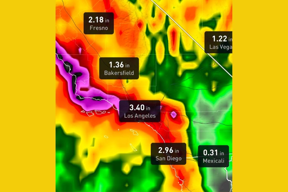
Current model projections highlight significant rainfall potential across several major cities. Los Angeles shows the highest projected total among the labeled locations at about 3.40 inches, followed by San Diego at roughly 2.96 inches. Farther north in the San Joaquin Valley, Fresno is projected near 2.18 inches, while Bakersfield sits around 1.36 inches.
Outside California, Las Vegas shows a projected total of about 1.22 inches, an unusually high amount for the Nevada desert. Across the border, Mexicali is projected to receive a much lighter total of around 0.31 inches.
Heaviest Amounts Focused on Coastal Mountains
The most intense rainfall on the projection map is concentrated along the coastal ranges and foothills northwest of Los Angeles, including areas near Santa Barbara County and Ventura County. These zones appear in the highest color categories, where some model output suggests localized totals could exceed 7 inches over the full period.
Mountain terrain often enhances rainfall as moist air is forced upward, which is why slopes and foothills frequently receive far more rain than nearby valleys and coastal cities. Small pockets of heavier rain also appear inland near the Inland Empire.
Possible El Niño and Jet Stream Influence
The developing pattern is being linked to a shift in the jet stream that could direct deeper Pacific moisture toward the West Coast. This type of setup can resemble a Pineapple Express, a moisture plume that originates near Hawaii and can deliver prolonged periods of heavy rain to California.
The ongoing El Niño in the Pacific Ocean is often associated with a more active southern storm track during the cool season. However, El Niño shifts seasonal odds rather than guaranteeing specific storms, so individual rainfall forecasts this far out should be treated as early guidance rather than certainty.
Flooding Concerns Should Be Monitored Closely
If rainfall totals verify near projected levels, flash flooding, urban flooding, and mud and debris flows could become concerns, particularly near recent burn scars and steep terrain. Heavy rain after a long dry season can produce rapid runoff because hardened soils absorb water slowly.
Residents in flood-prone neighborhoods, canyon communities, and areas below hillsides should begin reviewing preparedness plans. Clearing storm drains, checking gutters, and staying informed through National Weather Service forecasts are simple steps that can reduce risk.
Forecast Confidence Remains Limited
Rainfall projections more than a week out can shift considerably as new data arrives. The exact timing, storm track, and placement of the heaviest rain will become clearer over the coming days, and totals may rise or fall significantly from current estimates.
Residents planning Halloween activities, outdoor events, or travel across California and Nevada should keep an eye on updated forecasts and official alerts as the end of October approaches.
For continuing coverage of West Coast storms, flood alerts, and critical weather analysis across the United States, visit Weather Radar.