Warming Trend Pushes Arkansas Highs Into the Low to Mid 80s This Week as Extreme Fire Danger and Worsening Drought Grip the State
LITTLE ROCK, AR — After a weekend of incredible fall weather across Arkansas, a noticeable warming trend is on the way. Temperatures will climb steadily through the week, with the biggest jump arriving during the middle to late stages of the week. Highs will move into the 70s first before eventually reaching the low to even middle 80s, while a persistent dry pattern continues to worsen drought conditions and raise fire danger across the state.
Temperatures Climb Into the 80s by Late Week
The warmup will begin gradually, with afternoon highs settling into the 70s early in the week. As the week progresses, warmer air will build across the Southern Plains and the Mid-South, pushing highs into the low and middle 80s across much of Arkansas by the latter half of the week.
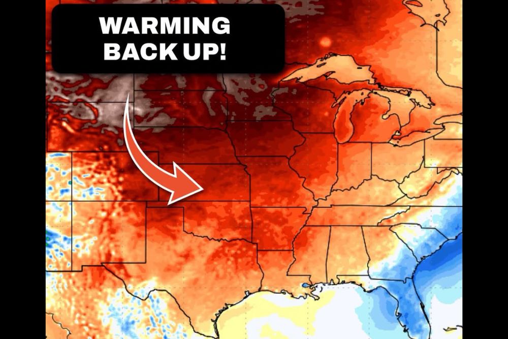
The temperature anomaly map shows a broad zone of above normal warmth spreading across the central United States, including Arkansas, Oklahoma, Kansas, Missouri, and Texas. This widespread warmth signals that the recent cool spell will take a break for at least the next several days.
South Arkansas Could Approach 90 Degrees
The warmest conditions are expected in South Arkansas, where temperatures could get close to the 90-degree mark late in the week. Even so, most locations across the state are expected to stay just below that threshold.
Forecasters remain hopeful that the 90s are finished statewide for the season. However, the extremely dry ground may allow temperatures to creep a little higher than normal, since dry soils heat up more efficiently under sunny skies than moist ones.
No Strong Cold Front in Sight
There are currently no signals for a strong cold front this week or early next week. Without a significant push of cooler air, the warm pattern will likely remain locked in place across Arkansas for an extended stretch.
The next meaningful shot of cooler air may not arrive until late October or early November. Until then, residents should expect warm afternoons, mild nights, and fairly steady conditions from day to day.
Little to No Rain in the Forecast
The dry pattern shows no signs of breaking anytime soon. Little to no rainfall is expected over the next several days, offering no relief for areas that have already gone weeks without meaningful precipitation.
This lack of moisture is a major concern for farmers, ranchers, gardeners, and anyone relying on local water sources. Ponds, creeks, and pastures across the state may continue to dry out as the warm and rainless stretch carries on.
Extreme Fire Danger and Expanding Drought
Some parts of Arkansas are already experiencing extreme fire danger along with an extensive drought that is expected to get much worse before it improves. Dry grass, fallen leaves, and parched vegetation can ignite easily, and warmer temperatures will only increase that risk.
Residents are strongly encouraged to avoid outdoor burning, follow any burn bans issued by local authorities, and use caution with equipment that can produce sparks. Properly discarding cigarettes and avoiding parking vehicles on dry grass can also help prevent accidental fires.
What Residents Should Expect Going Forward
The week ahead will bring warm, sunny, and dry conditions across Arkansas, with highs well above normal for late October. While the weather will be pleasant for outdoor activities, the growing drought and fire concerns make it important for residents to stay alert and follow local safety guidance until meaningful rain and cooler air finally return.
For continuing coverage of drought conditions, fire weather alerts, and critical weather analysis across the United States, visit Weather Radar.