Possible Nor’easter Could Hug the Maryland, Delaware and Virginia Coast Thursday, November 5 as a Deep Trough Sets Up Chilly Air for the Weekend
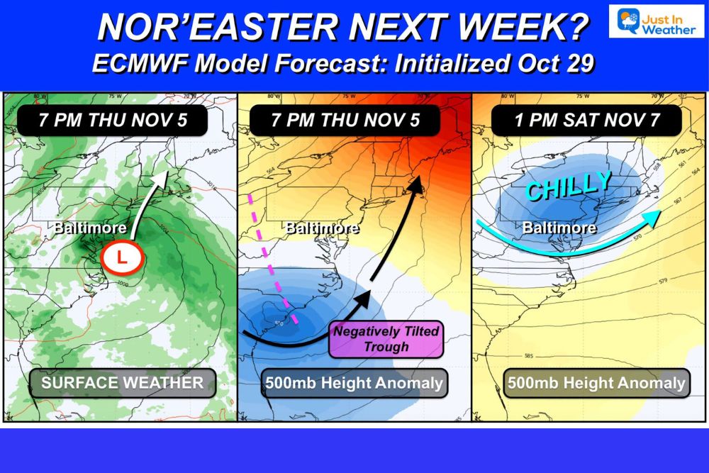
BALTIMORE, MD — A nor’easter may be taking shape along the Mid-Atlantic coast about one week from now. The latest ECMWF model, run on October 29, shows an area of low pressure moving up the shoreline on Thursday, November 5, steered by a deep negatively tilted trough in the upper atmosphere. Colder air is then expected to follow by the weekend of November 7. November will begin on the warm side, but this setup hints at a more active pattern with additional coastal storms possible in the weeks ahead.
Low Pressure Tracks Along the Coast
The surface weather forecast for 7 PM Thursday, November 5, shows a low pressure center positioned near the Delmarva Peninsula, just southeast of Baltimore. The storm is projected to move north and northeast along the coastline, spreading rain across Maryland, Delaware, Virginia, and parts of Pennsylvania and New Jersey.
A storm on this track could bring steady rain, gusty northeast winds, and rough surf to coastal communities, along with possible coastal flooding during high tide.
Negatively Tilted Trough Fuels the Storm
The upper-level forecast for the same time shows a deep trough digging into the Southeast, with a negative tilt stretching from the Carolinas northeastward. A negatively tilted trough leans from southeast to northwest and is often linked to rapidly strengthening storms.
This type of pattern can help draw a low pressure system up along the coast instead of pushing it out to sea, which is a common setup for classic nor’easters along the East Coast.
Chilly Air Arrives by Saturday
By 1 PM Saturday, November 7, the upper-level pattern shows a broad area of colder air settling over the Northeast and Mid-Atlantic. Baltimore and the surrounding region fall inside the chilly zone, signaling a noticeable drop in temperatures after the storm passes.
This would mark one of the first significant shots of fall chill for the region after an unusually warm and dry October.
Welcome Rain After a Dry Stretch
Much of Maryland and the Mid-Atlantic has gone more than a week without meaningful rain, and drought conditions have continued to worsen. A coastal storm could bring much-needed rainfall to the region, helping lawns, farms, and water supplies.
Forecast Still Uncertain
With the storm still about a week away, forecasters caution that the setup could change. Model runs over the next several days will help determine whether this trend holds firm or turns out to be a short-lived signal.
The track of the low will be key. A track farther offshore would bring lighter impacts, while a track closer to the coast could bring heavier rain and stronger winds.
Stay Tuned Through the Week
Residents across the Mid-Atlantic should keep an eye on forecast updates as the storm approaches.
For continuing coverage of nor’easter forecasts, Mid-Atlantic weather, and critical weather analysis across the United States, visit Weather Radar.