Severe Thunderstorm Warning With 60 MPH Winds and Possible Tornado Covers Ashland, Mellen and Cable in Northern Wisconsin Near the Michigan Line
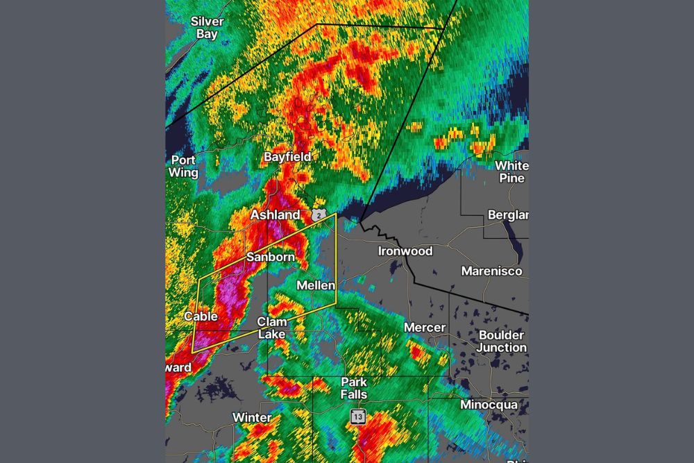
ASHLAND, WI — A Severe Thunderstorm Warning was issued on the evening of Wednesday, October 28, for parts of northern Wisconsin, with the warned area extending close to the Michigan state line. The warning highlighted the threat of 60 mph wind gusts and a possible tornado as a line of strong storms pushed northeast across the region. Radar imagery at 7:59 PM showed an intense band of storms stretching from near Cable north through Ashland and into Lake Superior.
Intense Storm Line Across Northern Wisconsin
Radar showed a long, narrow line of storms with deep red and magenta returns, indicating very heavy rainfall and strong winds. The most intense portion of the line stretched from near Hayward and Cable northeastward through Sanborn and Ashland, then out over Chequamegon Bay and Lake Superior near Bayfield.
The storm line was moving east toward Mellen, Ironwood, and the Michigan border, with heavy rain also spreading across the Apostle Islands region and the open waters of Lake Superior.
Communities Inside the Warning Area
The warning polygon covered portions of Ashland, Bayfield, and Sawyer counties. Communities including Ashland, Sanborn, Mellen, Cable, and Clam Lake were within or near the warned area.
The warning extended east toward the area around U.S. Highway 2, reaching close to the Michigan state line near Ironwood in Michigan’s Upper Peninsula.
Additional Storms Across the Region
Other strong storms were also visible farther south, including near Park Falls along State Highway 13, where pockets of heavy rain and strong winds were indicated. Additional activity extended toward Mercer, Boulder Junction, and Minocqua, as well as across Michigan’s western Upper Peninsula, including Marenisco, Bergland, and White Pine.
Forecasters remained on standby for additional warnings throughout the evening as the storms continued moving east.
Late October Severe Weather in the Northwoods
Severe thunderstorms are relatively uncommon in northern Wisconsin this late in the season. The storms developed ahead of a strong cold front associated with a low pressure system moving across the Upper Midwest, where unusually warm and humid air for late October helped fuel the activity.
Safety Reminders
Residents in the warned area should move indoors to a sturdy building and stay away from windows. 60 mph winds can bring down trees and power lines, causing outages and blocking roads. If a tornado warning is issued, residents should move to an interior room on the lowest floor.
Boaters on Lake Superior should seek safe harbor immediately, as strong winds and lightning create dangerous conditions on the water.
Damage Reports to Follow
Any reports of storm damage or possible tornado touchdowns will be reviewed by the National Weather Service in the coming days.
For continuing coverage of severe storms, Upper Midwest weather, and critical weather analysis across the United States, visit Weather Radar.