Dry Hole Grips the Eastern U.S. From Michigan and Ohio to Georgia and Texas as Little Rain Falls Before Moisture Returns October 28
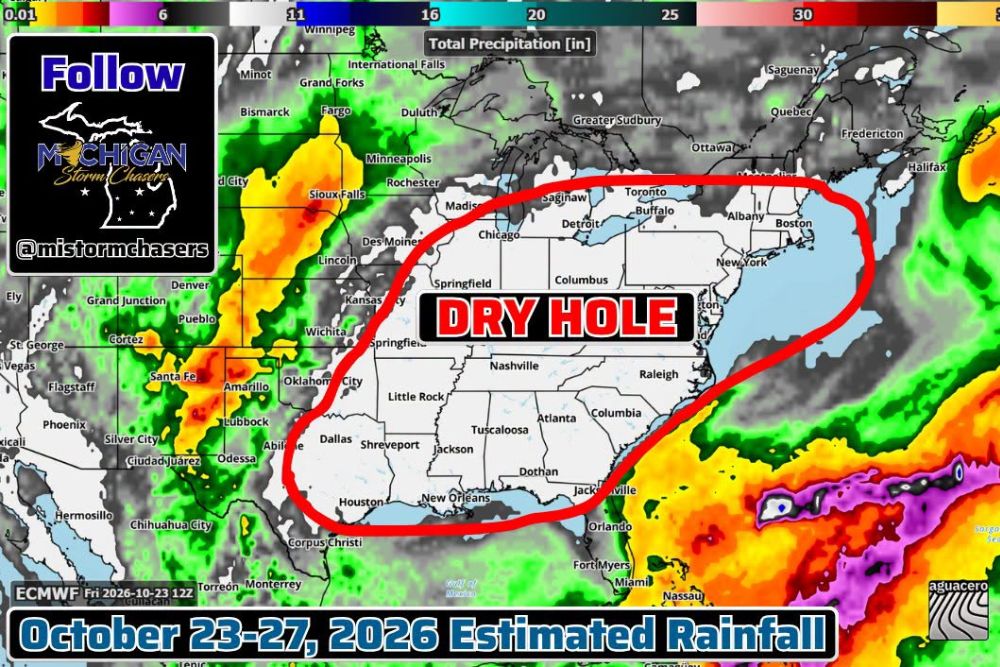
DETROIT, MI — Nearly the entire eastern half of the United States is stuck in a persistent dry pattern, with model guidance showing a large dry hole stretching from the Great Lakes to the Gulf Coast. Outside of the tropical system that affected the Mississippi and Alabama region earlier this month, much of the East has seen plenty of dry days. The dryness is expected to continue through at least the next four days, with moisture finally beginning to advance north out of the Great Plains by around October 28.
A Massive Dry Zone Across the East
Estimated rainfall from the ECMWF model for October 23 through 27 shows almost no precipitation across a huge area. The dry zone covers Michigan, Ohio, Indiana, Illinois, Kentucky, Tennessee, Georgia, Alabama, Mississippi, Arkansas, the Carolinas, Virginia, and much of the Northeast.
Major cities inside the dry hole include Detroit, Chicago, Columbus, Nashville, Atlanta, Raleigh, New York, Boston, Little Rock, Jackson, and New Orleans. Even Dallas, Shreveport, and Houston in the South Central states sit along the western edge of the dry zone.
Rain Focused Over the West and Southern Plains
While the East stays dry, rainfall is concentrated farther west. Model data shows wetter conditions across New Mexico, Colorado, the Texas Panhandle, and western Oklahoma, including areas near Santa Fe, Amarillo, Lubbock, and Pueblo.
Rain is also shown across parts of the Northern Plains, including the Dakotas, Nebraska, and Minnesota, as storm systems move through the central part of the country.
Heavy Rain Stays Offshore in the Atlantic
The heaviest rainfall on the map is located well offshore in the Atlantic Ocean, east of Florida and the Southeast coast. This moisture remains far from land and is not expected to bring relief to the dry areas along the East Coast.
Parts of the Florida Peninsula, including areas near Orlando, Fort Myers, and Miami, may see some light rainfall, but amounts appear limited compared to totals over the open water.
Moisture Expected to Return by October 28
The dry stretch may finally begin to break down around October 28, when moisture is expected to advance northward out of the Great Plains. This shift could bring the first meaningful rain chances in some time to parts of the Midwest, Great Lakes, and eventually the East.
However, this outlook is based on a single deterministic model run, which can change from one update to the next. Exact timing and rainfall totals will become clearer as the date approaches.
Concerns Over Growing Dryness
The extended dry spell continues to raise concerns about drought, low water levels, and elevated fire danger across many states. Dry vegetation and fallen leaves can ignite easily, so residents are encouraged to use caution with outdoor burning and follow any local restrictions.
Farmers and gardeners may also feel the effects as soil moisture continues to decline heading into late fall.
Watching for a Pattern Change
For now, the eastern United States remains locked in a dry pattern with mostly sunny skies. Residents should continue monitoring forecasts for signs of the expected shift later next week.
For continuing coverage of drought updates, rainfall outlooks, and critical weather analysis across the United States, visit Weather Radar.