Rare Anticyclonic Storm Triggers a Tornado Warning West of Show Low, Arizona as Storm Chasers Track the Rotation Near Pinetop and Taylor
SHOW LOW, AZ — A tornado warning was issued for a rotating thunderstorm west of Show Low in eastern Arizona, as an unusual anticyclonic mesocyclone developed over the White Mountains region of Navajo County. Radar velocity data showed a distinct area of rotation southwest of town, prompting the warning as storm chasers moved in to track the system. The event adds to an already remarkable stretch of severe weather across Arizona this week.
What Makes This Storm Unusual
Most rotating thunderstorms in the Northern Hemisphere spin counterclockwise, known as cyclonic rotation. This storm instead featured anticyclonic rotation, meaning it was spinning clockwise. Anticyclonic mesocyclones are relatively rare and often develop when storms split apart, with the left-moving portion of the storm sometimes rotating in the opposite direction.
While less common, anticyclonic storms can still produce tornadoes, large hail, and damaging winds, which is why the National Weather Service treats them with the same level of caution as typical rotating storms.
Radar Shows Rotation Southwest of Show Low
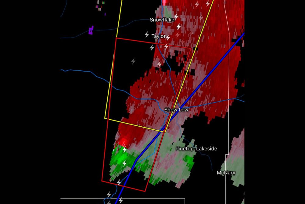
Velocity radar imagery revealed a clear couplet of inbound and outbound winds southwest of Show Low, near the area between town and Pinetop-Lakeside. Strong red returns, representing winds moving away from the radar, sat close to bright green returns, representing winds moving toward the radar. This tight pairing is a key indicator of rotation within a storm.
Frequent lightning strikes were also detected across the region, including near Taylor, Snowflake, and areas along the main highway corridor through the warning zone.
Warning Area Covers Several Communities
The tornado warning polygon stretched from areas southwest of Show Low northeastward toward Taylor, covering portions of the main travel corridor through the region. A larger severe thunderstorm warning area extended to the north, including areas near Snowflake.
Nearby communities such as Pinetop-Lakeside and McNary were located close to the storm’s path, and residents across the area were urged to stay alert and monitor official alerts for updates.
Part of a Historic Severe Weather Stretch
This warning comes during an exceptionally active severe weather period for Arizona, which recently saw a rare Level 3 out of 5 severe weather risk issued for parts of the state. The Mogollon Rim and White Mountains have been among the areas with the greatest potential for rotating storms, as moisture, instability, and wind shear came together in an unusual setup for late October.
Tornadoes remain uncommon in Arizona, making this week’s activity especially notable for residents and forecasters alike.
Safety Reminders for Residents
During a tornado warning, residents should move immediately to an interior room on the lowest floor of a sturdy building, away from windows. Mobile homes and vehicles offer little protection, so those in such shelters should seek a safer location quickly when time allows.
Travelers on highways through the region should avoid driving into storms, pull over safely if visibility drops, and never take shelter beneath overpasses.
Damage Assessments to Follow
Any confirmed tornado touchdowns, damage reports, or official ratings will come from the National Weather Service following storm surveys in the coming days.
For continuing coverage of severe storms, tornado warnings, and critical weather analysis across the United States, visit Weather Radar.