Very Strong El Niño Could Bring Drought Relief to Arkansas as Past Events Delivered Above Average November and December Rain in the Mid-South
LITTLE ROCK, AR — After an extremely dry stretch that has persisted since the end of spring 2025, Arkansas may finally be approaching a turning point. Historical climate data shows that during very strong El Niño events, the state has typically seen above average rainfall in November and especially December. With a powerful El Niño now developing in the Pacific Ocean, the seasonal outlook offers growing hope that the ongoing drought could begin to ease this winter.
Historical El Niño Years Point to a Wetter End of the Year
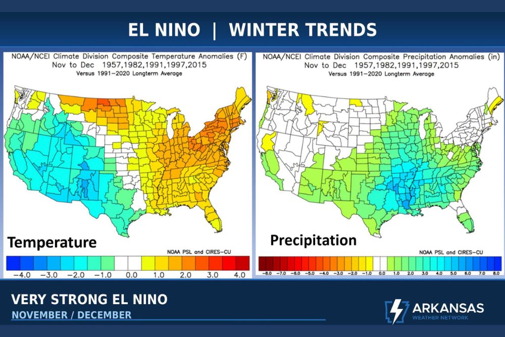
Climate composites from NOAA and NCEI examined five past very strong El Niño years, including 1957, 1982, 1991, 1997, and 2015. The analysis compares November and December conditions during those years with the 1991 to 2020 long-term average.
The precipitation composite shows a clear wet signal across much of the central and southern United States. The strongest positive anomalies appear across Arkansas, Louisiana, Mississippi, Tennessee, and Alabama, where rainfall during those years ran well above normal, in some areas by several inches.
Arkansas Sits Near the Center of the Wet Signal
Arkansas falls within one of the most favorable zones on the historical rainfall map. Much of the state shows positive precipitation anomalies, with the eastern half and the Mississippi River Delta region among the wettest areas. Neighboring Louisiana and Mississippi show some of the highest anomalies in the entire country.
This pattern reflects the typical behavior of a strong southern jet stream during El Niño, which tends to steer repeated storm systems across the Southern Plains, Mid-South, and Gulf Coast during the cool season.
Temperature Trends Show a Split Across the Country
The temperature composite for the same years shows a notable divide. Much of the western United States and the Southwest ran cooler than average, while the northern Plains, Great Lakes, Ohio Valley, and Northeast trended warmer than normal during November and December.
Arkansas sits near the transition zone, with portions of the state showing slightly warmer than average conditions. Temperatures across the Southeast, including Georgia and the Carolinas, also trended warmer during those past events.
One of the Driest Periods in Recent Memory
The current drought ranks among the most severe in recent memory across Arkansas, with conditions this dry only seen a handful of times over several decades. Lakes, ponds, pastures, and farmland across the state have felt the impact, while dry vegetation has raised fire danger in many communities.
Farmers, ranchers, and water managers are hoping for a significant pattern change, as meaningful rainfall would help restore soil moisture and recharge local water supplies heading into the new year.
Seasonal Outlooks Show Odds, Not Guarantees
Broad seasonal forecasting can be successful when strong climate drivers such as El Niño are in place. However, historical patterns indicate probabilities rather than certainties, and each El Niño event can behave differently. Individual storms and rainfall totals will still depend on the timing and track of each system.
Hope for a Turnaround This Winter
Every drought eventually comes to an end, and the strong El Niño setup gives Arkansas a reasonable chance at relief over the coming months. Residents should continue following local forecasts as November begins, as the first signs of a wetter pattern may arrive in the weeks ahead.
For continuing coverage of El Niño trends, drought updates, and critical weather analysis across the United States, visit Weather Radar.