Storm Brings Thunderstorms, Flooding and Sierra Snow to California on Wednesday and Thursday as a Few Waterspouts May Form Off the Coast
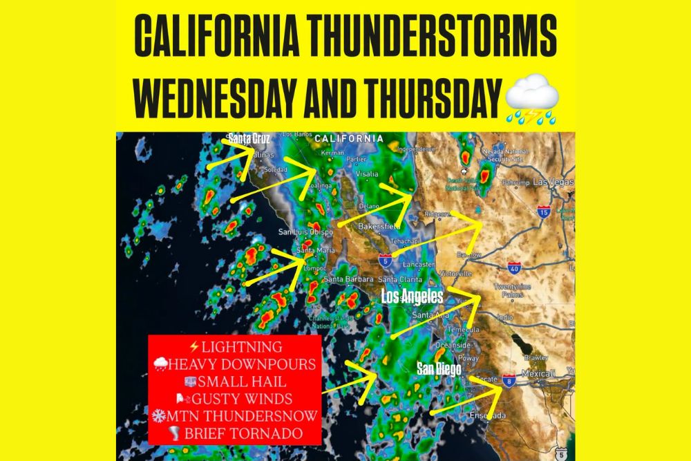
LOS ANGELES, CA — A potent storm system is set to bring showers and scattered thunderstorms to large parts of California on Wednesday and Thursday, with lightning, heavy downpours, small hail, and gusty winds all possible. The setup features increasing moisture, colder air aloft, and strong upper-level winds, a combination that can support organized storms. While many locations will see rain without thunder, the storms that do form could produce intense bursts of rainfall and localized flooding.
Thunderstorm Chances Spread Across the State
Thunderstorm opportunities extend across parts of Northern and Central California, including the Central Coast, the San Joaquin Valley, and Southern California. Areas such as Santa Cruz, Salinas, Coalinga, Visalia, Bakersfield, San Luis Obispo, and Santa Maria are all within the region expected to see showers and storms.
Storms may also extend inland toward the Mojave Desert, with activity possible near Ridgecrest, Barstow, and Victorville, and into southern Nevada near Las Vegas and Pahrump.
Timing for Southern California Counties
For Santa Barbara, Ventura, and Los Angeles counties, the main storm window looks to be Wednesday afternoon through Thursday morning. Farther south across Orange County, San Diego, and the Inland Empire, thunderstorm chances are favored from Wednesday night into Thursday afternoon.
Communities including Santa Clarita, Lancaster, Santa Ana, Temecula, Oceanside, and Poway should prepare for periods of heavy rain during these windows.
Flooding and Debris Flow Concerns Near Burn Scars
Locally intense downpours could cause flooding, especially in urban areas with poor drainage and around recent burn scars. Burned hillsides absorb water poorly, which allows rain to rush downhill quickly and carry mud, rocks, and debris with it.
Debris flows are possible in vulnerable foothill and canyon communities. Residents living below burn areas should have an evacuation plan ready, monitor local alerts, and avoid driving through flooded roads or washes.
Waterspouts and a Brief Tornado Possible
A few storms could develop rotation, and isolated waterspouts are possible along the Southern California coast. A brief tornado cannot be ruled out if a rotating storm moves ashore, though that threat remains low and conditional.
The San Joaquin Valley could also see some rotating storms, but limited instability may prevent stronger storms from developing there. Anyone at beaches, harbors, or on the water should head indoors at the first sign of lightning or an approaching storm.
High Elevation Snow and Mountain Thundersnow
The colder air will also bring high-elevation snow. Snow levels may fall to around 7,000 feet in the Sierra Nevada and near 8,000 feet in Southern California. The Sierra could pick up several inches of snow, while light accumulations are possible on the highest peaks of the San Bernardino and San Jacinto mountains.
Mountain thundersnow, a rare event in which lightning occurs during snowfall, is also possible in the higher terrain. Travelers heading into the mountains should prepare for slick roads and changing conditions.
What Residents Should Expect
Residents across California should plan for a stormy midweek stretch, with the most active weather arriving between Wednesday and Thursday afternoon. Staying updated with National Weather Service alerts will be important, especially for those near burn scars, along the coast, or traveling through mountain passes.
For continuing coverage of California storms, flood alerts, and critical weather analysis across the United States, visit Weather Radar.