Tornado Threat Builds Across Kansas, Oklahoma and North Texas Monday Evening as Severe Storms Target Wichita and Oklahoma City Well After Sunset
OKLAHOMA CITY, OK — A tornado threat is developing across the Southern Plains for Monday, November 2, as a strong storm system moves into the region. Severe thunderstorms are expected across portions of Kansas, Oklahoma, and northern Texas, with the greatest threat arriving Monday evening between 6:00 PM and midnight CST. Storms are expected to form first across western Oklahoma and northwest Texas before spreading east. A few tornadoes are possible, especially after sunset, raising concerns about dangerous storms overnight.
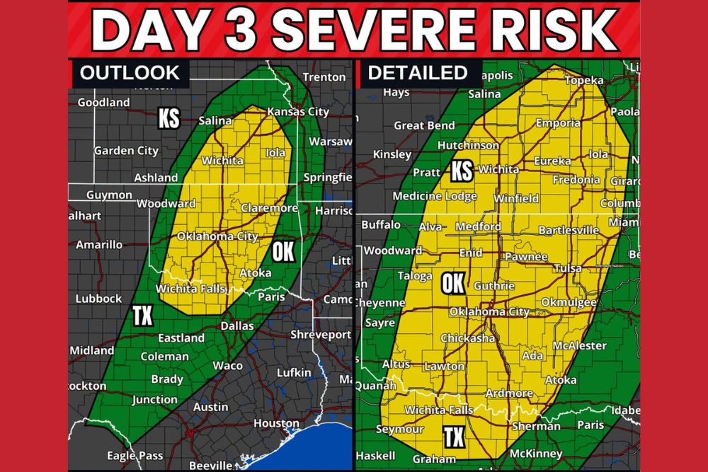
Day 3 Outlook Covers Three States
The Day 3 severe weather outlook highlights a slight risk area stretching from central Kansas south through Oklahoma and into North Texas. Cities within this zone include Wichita, Salina, Iola, Oklahoma City, Claremore, Atoka, and Wichita Falls.
A broader marginal risk surrounds this area, extending from Garden City and Kansas City in Kansas through Woodward and western Oklahoma, and south into Texas near Dallas, Waco, Eastland, Coleman, Brady, and Junction.
Detailed Look at the Higher Risk Area
A closer view shows the slight risk zone covering much of central and eastern Oklahoma and south central Kansas. Communities include Hutchinson, Emporia, Winfield, Enid, Ponca City, Bartlesville, Tulsa, Guthrie, Okmulgee, Chickasha, Lawton, Ada, McAlester, and Ardmore.
In Texas, the risk zone includes Wichita Falls, Seymour, Graham, Sherman, and McKinney, near the northern edge of the Dallas-Fort Worth area.
Primary Threats
The main threats Monday evening include:
A few tornadoes, especially after sunset, when storms may still be organized and rotating.
Damaging wind gusts, particularly as storms grow into lines while moving east.
Rotating supercells early in the event, followed by organized lines of thunderstorms later in the night.
Overnight Severe Weather Concern
Because the most dangerous storms may arrive late in the evening and overnight, forecasters urge residents to have multiple ways to receive weather warnings. Phone alerts, NOAA weather radios, and local broadcasts can all help ensure warnings reach people who may already be asleep.
Nighttime tornadoes are especially dangerous because they are harder to see and many people may not hear outdoor sirens indoors.
Prepare Before Monday Evening
Residents should review shelter plans, keep shoes and a flashlight nearby, and make sure phones are charged before going to bed Monday night. Forecast details and the areas at greatest risk may still change as the event approaches.
For continuing coverage of Southern Plains severe storms, tornado alerts, and critical weather analysis across the United States, visit Weather Radar.