Radar Estimates More Than 16 Inches of Rain in West Central Pearl River County, Mississippi as Flash Flood Emergency Brings Rescues Near Bogalusa
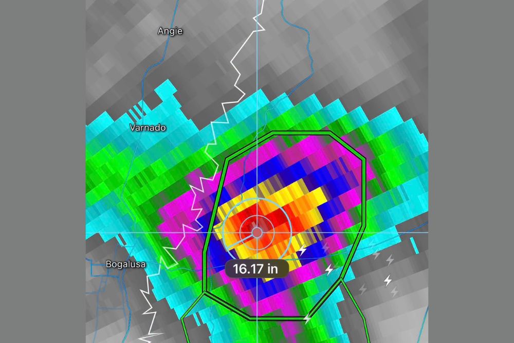
PEARL RIVER COUNTY, MS — A Flash Flood Emergency remains in effect for west central Pearl River County in southern Mississippi, where radar estimates show more than 16 inches of rain has fallen. The highest radar estimate reached 16.17 inches, an extraordinary total for a single storm event. Flash flooding is already occurring, with ongoing high-water rescues and swift-moving water covering multiple roadways in the area just east of Bogalusa, Louisiana.
Radar Shows an Intense Rainfall Core
Radar-estimated rainfall imagery shows a concentrated core of extreme rain centered inside the Flash Flood Emergency polygon. The heaviest totals, shown in red, orange, and yellow, sit just east of the Pearl River and the Mississippi-Louisiana state line.
Surrounding the core, bands of blue and magenta indicate rainfall totals well above several inches, while lighter totals spread outward toward Varnado and Angie in Louisiana and toward Bogalusa.
Rescues Underway Across the Area
Emergency crews continue to respond to high-water rescues as rising water traps residents in homes and vehicles. Earlier reports included flooding on Old Camp Road, swift water on Highway 26 near North Valley Road, and a rescue on Humphrey Road near Crossroads.
Lightning was still being detected near the flood zone, showing that thunderstorms remained active over the area.
Among the Most Extreme Rain Events in the Region
Rainfall totals above 16 inches in a short period are extremely rare, even along the rainy Gulf Coast. Other radar estimates in the area have shown totals as high as 17.4 inches, while emergency management earlier confirmed 6 to 10 inches of observed rainfall.
Such extreme totals can overwhelm creeks, ditches, culverts, and small rivers within hours, causing widespread flooding of roads and property.
What Caused the Flooding
The storms formed as deep Gulf of Mexico moisture surged into the Deep South during an increasingly active El Niño pattern. Thunderstorms repeatedly developed and moved over the same area, allowing rainfall totals to pile up rapidly.
Stay Off Flooded Roads
Residents should avoid all travel in the affected area unless evacuating to higher ground. Drivers should never attempt to cross flooded roads, as moving water can quickly sweep vehicles away. Anyone trapped by floodwater should call 911 and move to the highest point possible.
Rivers May Keep Rising
Runoff from the extreme rainfall may cause the Pearl River and nearby creeks to continue rising over the coming days, prolonging flood concerns for communities downstream.
For continuing coverage of Mississippi flooding, Gulf Coast storms, and critical weather analysis across the United States, visit Weather Radar.