Long Range Model Hints at a Thanksgiving Arctic Blast With Snow From Kansas to Pennsylvania and Flakes Possible in Mississippi and Alabama
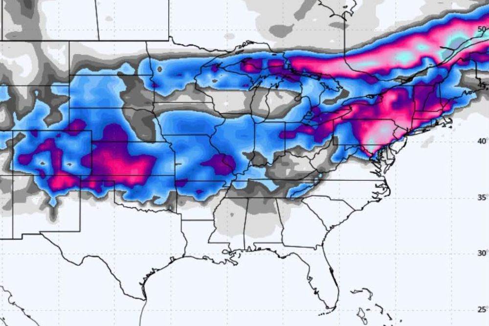
JACKSON, MS — A very long range forecast model scenario is drawing attention for showing a possible Arctic blast around Thanksgiving, with snow spreading across a large part of the country and even reaching parts of Mississippi and Alabama. The model output shows widespread snowfall from the Central Plains through the Midwest, Ohio Valley, and Northeast. However, forecasters stress this is not a Thanksgiving forecast. With the holiday still nearly four weeks away, the timing, snowfall, and how far south any cold air reaches all remain highly uncertain.
Snow Shown Across the Plains and Midwest
The model shows a broad swath of snow stretching from New Mexico, Colorado, and Kansas eastward across Oklahoma, Missouri, Iowa, and Illinois. Some of the heavier totals, shown in pink and purple, appear across western Kansas, southeastern Colorado, and northeastern New Mexico.
Snow also extends across Nebraska, South Dakota, Minnesota, Wisconsin, and Michigan, along with Indiana and Ohio.
Heaviest Totals in the Northeast
The model highlights some of its heaviest snowfall across the Appalachians and Northeast, including Pennsylvania, New York, and parts of New England. A band of heavier snow also appears across western Virginia, West Virginia, and Maryland.
Snow extends into southern Canada, including areas near the St. Lawrence River, where the model shows a long stripe of heavy totals.
Light Snow Reaching the Deep South
The most eye-catching part of the model is the light snow shown across portions of northern Mississippi and Alabama, as well as Tennessee, Arkansas, and Kentucky. These areas appear in lighter shading, suggesting only a dusting to light accumulation if the scenario were to play out.
Snow in the Deep South around Thanksgiving would be unusual, but it is not unheard of when strong Arctic air plunges far south.
Why Forecasters Urge Caution
Long range model runs several weeks out often change dramatically from one update to the next. A single model run showing snow does not mean snow is likely. Forecasters rely on consistent trends across many runs and multiple models before gaining confidence in any outcome.
Factors such as the polar vortex, El Niño, and the position of the jet stream will all play a role in determining whether Arctic air reaches the southern United States in late November.
Don’t Change Holiday Plans Yet
Families should not rearrange Thanksgiving plans based on a single long range model image. More reliable forecasts will become available closer to the holiday, typically within about a week of the event.
Watching the Pattern
Forecasters will continue tracking signs of colder air as November progresses, especially any disruption to the polar vortex that could send Arctic air south.
For continuing coverage of Thanksgiving forecasts, winter outlooks, and critical weather analysis across the United States, visit Weather Radar.