Last Winter’s Stratospheric Warming Brought Up to 13 Inches of Snow to Iowa, Wisconsin and Illinois as Forecasters Watch for a Repeat
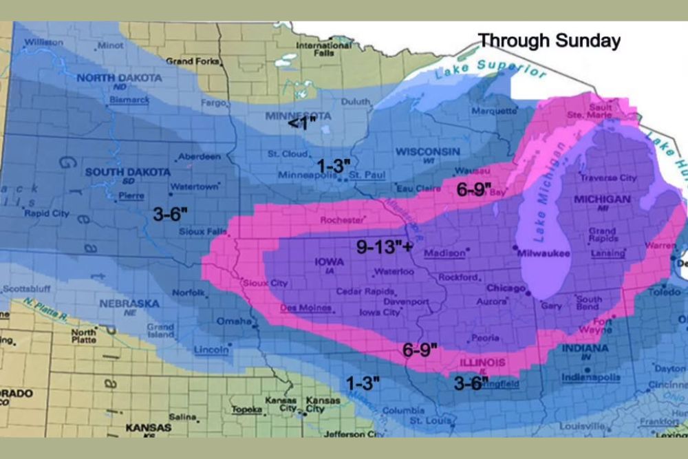
DES MOINES, IA — Forecasters are looking back at last winter for clues about what the coming season could bring. Late last November, an early Sudden Stratospheric Warming event, known as an SSW, set off a chain reaction in the atmosphere that eventually produced a major winter storm across the Midwest. Snowfall totals from that storm reached 9 to 13 inches or more in parts of Iowa, Wisconsin, and Illinois. With signs of a weakening polar vortex this fall, forecasters are watching for a similar setup, though this year comes with one major difference: a strong El Niño.
What Is a Sudden Stratospheric Warming
A Sudden Stratospheric Warming occurs when temperatures high above the Arctic, in a layer of the atmosphere called the stratosphere, rise sharply over a short period. This warming can weaken or disrupt the polar vortex, the large band of cold air that usually stays locked near the North Pole.
When the vortex is disrupted, cold Arctic air can spill southward into the United States, often days or weeks later. That shift can set the stage for major winter storms and sharp cold outbreaks.
Last Winter’s Big Midwest Snowstorm
After last year’s late November SSW, a significant winter storm moved across the Upper Midwest. The heaviest snow, 9 to 13 inches or more, fell across a band stretching from northern Iowa through Waterloo, Cedar Rapids, and Dubuque into southern Wisconsin near Madison and Rockford.
Totals of 6 to 9 inches extended across central Wisconsin, including Wausau and Green Bay, and into Michigan, including Grand Rapids, Lansing, and Traverse City. Parts of Illinois, Indiana, and northern Missouri also picked up 6 to 9 inches.
Lighter Totals Around the Edges
Snow totals were lighter farther away from the storm’s center. Minneapolis and St. Paul saw about 1 to 3 inches, while areas near Sioux Falls and eastern South Dakota received 3 to 6 inches. Southern Illinois near Springfield picked up 3 to 6 inches, while Kansas City and northern Missouri saw only 1 to 3 inches.
Northern Minnesota near Duluth and International Falls received less than 1 inch.
Storm Location Can Shift Hundreds of Miles
Forecasters caution that while SSW events often lead to winter storms, the exact location can vary by hundreds of miles. A storm that hits the Midwest one year could target the Plains, Ohio Valley, or East Coast in another.
How El Niño Could Change the Outcome
This year, a strong El Niño is in place. El Niño typically energizes the southern storm track, sending more storm systems across the southern United States. If an SSW sends cold air south at the same time, the combination could favor winter storms farther south than last year.
Watching the Polar Vortex
Forecasters will continue monitoring the stratosphere through November for signs of disruption.
For continuing coverage of winter outlooks, polar vortex updates, and critical weather analysis across the United States, visit Weather Radar.