Cutoff Low Could Send a Line of Storms Across Georgia, Florida, Alabama and the Carolinas Around November 5 as El Niño Fuels Southern Storms
ATLANTA, GA — An active weather setup is brewing for the Southeast later next week, with forecast models consistently showing a line of storms sweeping east around Thursday, November 5. The system is tied to a cutoff low in the upper atmosphere over the South Central United States, which is expected to pull a frontal line of thunderstorms across Alabama, Georgia, Florida, and the Carolinas. Forecasters say El Niño appears to be driving this early season activity, though the exact timing and severity remain uncertain. This system is a frontal storm line, not a hurricane.
Cutoff Low Over Texas and Louisiana
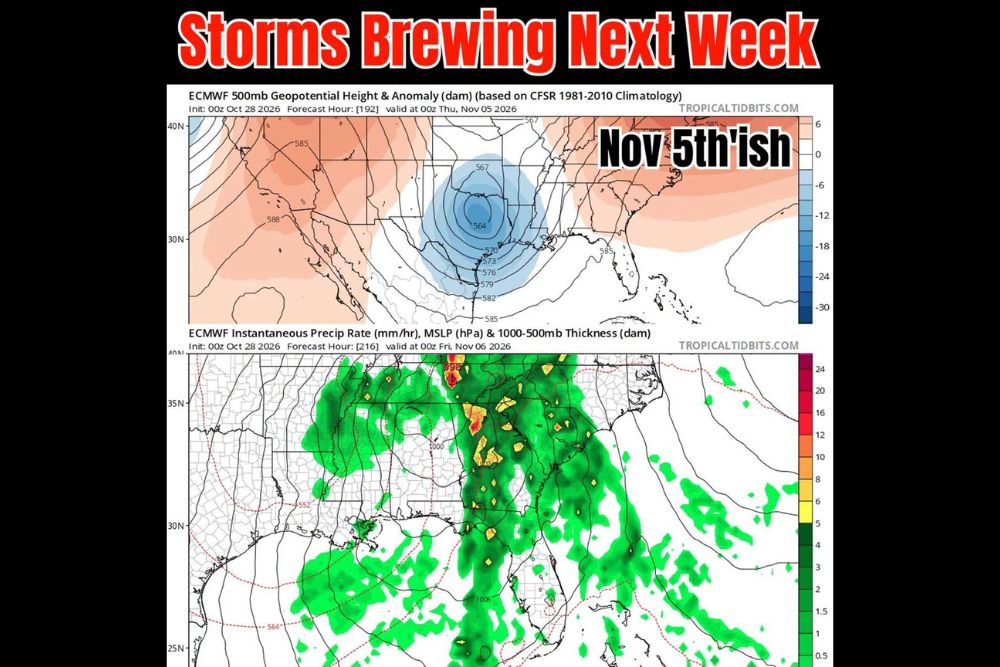
The ECMWF upper air forecast valid for early Thursday, November 5, shows a well-defined cutoff low centered over eastern Texas and Louisiana. A cutoff low is an area of low pressure aloft that becomes separated from the main jet stream flow, often moving slowly and producing prolonged periods of unsettled weather.
As this low gradually shifts east, it is expected to pull moisture northward from the Gulf of Mexico and help organize a line of storms ahead of an advancing cold front.
Line of Storms Moves Across the Southeast
The precipitation forecast valid for early Friday, November 6, shows a long band of rain and thunderstorms stretching from Tennessee and western North Carolina south through Georgia, Alabama, and into Florida. Heavier embedded storms, shown in yellow, orange, and red, appear across portions of Georgia and the western Carolinas.
The rain shield also extends into north and central Florida and over the Gulf of Mexico, while lighter rain spreads across Mississippi and Alabama behind the main line.
El Niño Driving Early Activity
El Niño tends to strengthen the subtropical jet stream, steering storm systems across the southern United States during the cool season. Forecasters say this pattern appears to be setting up earlier than usual, bringing increased chances for rain and storms to the Southeast and Florida as November begins.
This shift comes after an extended stretch of dry weather across much of the region, where drought conditions have worsened over recent weeks.
Severity Still Unclear
While models have shown a consistent signal for this storm system, the severity of the storms remains uncertain. Factors such as wind shear, instability, and the exact track of the cutoff low will determine whether storms become strong or severe.
Residents across the Southeast should keep an eye on forecasts as the event draws closer, especially since late fall storms can sometimes produce damaging winds and isolated tornadoes.
Timing May Shift
Forecasters note that the timing of the system could shift by a day or so as new data arrives. Cutoff lows are often difficult to predict precisely, as their slow movement can change from one model run to the next.
Welcome Rain for Dry Areas
Although storms may bring some hazards, the rainfall would provide welcome relief to drought-stricken areas across Georgia, Alabama, and the Carolinas.
For continuing coverage of Southeast storms, El Niño updates, and critical weather analysis across the United States, visit Weather Radar.