Slightly Cooler Tuesday Brings Mid to Upper 60s to Maryland and Washington as Dry Streak Reaches Nine Days and Halloween Looks Warm and Dry
BALTIMORE, MD — Tuesday, October 27, is shaping up to be a slightly cooler day across Maryland, Washington, D.C., Delaware, and southern Pennsylvania, with highs mostly in the mid to upper 60s. Clouds will return tonight and tomorrow, but the region will stay dry. It has now been nine days since the last rain, and the earliest chance for any showers may not arrive until Sunday or Monday. Meanwhile, Halloween is looking warm and dry for trick-or-treaters across the region.
Tuesday Highs Across the Region
Afternoon highs will settle into the mid to upper 60s for most of the area. Washington, D.C., is expected to be among the warmest spots at around 70 degrees, while Baltimore and Annapolis reach about 69 degrees. La Plata is forecast near 69 degrees, with Cambridge around 68 degrees and Easton about 69 degrees.
Farther north, Harrisburg, Lancaster, Gettysburg, and York are expected to top out near 66 degrees. Philadelphia reaches about 65 degrees, while Hagerstown and Frederick climb to around 68 degrees. Along the coast, Ocean City is forecast near 63 degrees, with Dover and Georgetown around 66 degrees.
Clouds Return but Rain Stays Away
The futurecast shows clouds moving into the region from the west by Tuesday afternoon, spreading across central and northern Maryland into tonight. Despite the increasing cloud cover, no rainfall is expected through Wednesday.
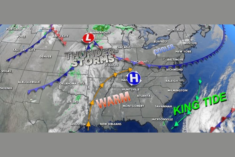
High pressure centered over the Tennessee Valley continues to steer storm systems away from the Mid-Atlantic, keeping dry conditions locked in place.
Storms Stay Focused on the Central U.S.
The surface weather map shows a low pressure system near Minneapolis, with a frontal boundary stretching across the Midwest and into the Ohio Valley. Thunderstorms are developing across the Plains, including areas near St. Louis, Omaha, and Oklahoma City.
Warm air continues flowing north from the Gulf Coast into the Southeast, while cooler air remains positioned across the Northeast near New York and Boston.
Jet Stream Pattern Keeps the East Warm
The ECMWF jet stream forecast for Monday evening shows a stormy pattern across the western and central United States, while the East Coast stays under a warmer, ridge-dominated pattern. This setup explains why the region continues to stay dry and mild even as storms remain active farther west.
King Tides Along the Coast
King tides remain a concern along parts of the Southeast and Atlantic coastline. Coastal residents should keep an eye on high tide cycles, which may cause minor flooding in low-lying areas.
Clocks Fall Back Sunday
There are just five days until clocks move back one hour early Sunday morning as Daylight Saving Time ends. Residents should remember to adjust their clocks before bed on Saturday night.
For continuing coverage of Mid-Atlantic forecasts, Halloween weather, and critical weather analysis across the United States, visit Weather Radar.