Experimental NOAA Model Hints at a Snowy Winter for Missouri, Kentucky, Ohio and the Dakotas as Clashing Jet Streams Could Fuel Big Storms
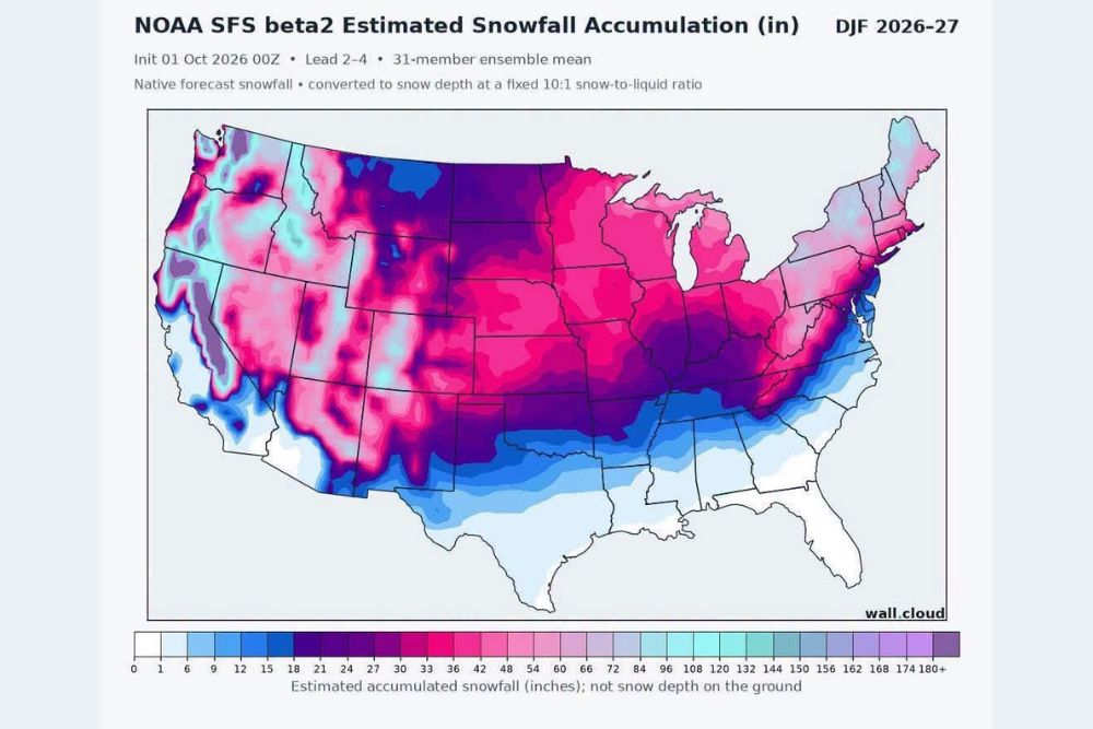
ST. LOUIS, MO — An experimental seasonal model from NOAA is pointing toward a potentially snowy winter across a large portion of the United States for December 2026 through February 2027. The NOAA SFS beta2 model’s estimated snowfall map shows widespread accumulations across the Northern Plains, Midwest, Ohio Valley, and Rocky Mountains, with notable totals extending surprisingly far south into states such as Missouri, Kentucky, and Tennessee. Forecasters say the interaction between the polar jet stream and the subtropical jet stream could help produce big winter storms, though it is far too early to know where they will strike.
What the Model Shows
The snowfall projection is based on a 31-member ensemble mean initialized on October 1, 2026, covering the three core winter months. The model converts forecast precipitation into snowfall using a fixed 10-to-1 snow-to-liquid ratio, and the totals represent accumulated snowfall, not the depth of snow on the ground at any one time.
Because the model is experimental and seasonal in scope, its output should be viewed as a broad signal rather than a specific forecast for any city or storm.
Heaviest Totals Across the Rockies and Northwest
The largest snowfall totals on the map appear across the higher terrain of the Rocky Mountains, the Cascades, and the Sierra Nevada. Mountain areas in Washington, Oregon, Idaho, Montana, Wyoming, Colorado, and Utah show seasonal totals that could exceed several feet, which is typical of a healthy winter in the high country.
Lower elevations across the interior West, including parts of Nevada and Arizona, show lighter but still notable accumulations in some areas.
Plains and Midwest Show Widespread Snow
A broad swath of significant snowfall stretches across the Northern and Central Plains, including North Dakota, South Dakota, Nebraska, and Kansas. The pattern continues eastward through Minnesota, Iowa, Wisconsin, Illinois, Indiana, Michigan, and Ohio, where seasonal totals appear well into double digits.
Some of the deepest colors on the map outside the mountains fall across Missouri, Kentucky, southern Illinois, and southern Indiana, suggesting the model favors an active storm track through the Ohio Valley and Mid-Mississippi Valley.
Snow Extends Into the South and Mid-Atlantic
The model also shows meaningful snowfall reaching Oklahoma, Arkansas, Tennessee, and northern portions of Mississippi, Alabama, and Georgia. Along the East Coast, accumulations extend through Virginia, Maryland, Pennsylvania, New Jersey, New York, and New England.
Areas along the Gulf Coast, Florida, and much of Texas show little to no snow, as expected.
Jet Stream Interaction Could Be Key
During strong El Niño winters, the subtropical jet stream often becomes more active, sending storm systems across the southern United States. When those systems interact with cold air delivered by the polar jet stream, the result can be powerful winter storms with heavy snow and ice.
Not an Official Forecast
This model output is experimental and should not be treated as an official forecast. Seasonal outlooks can shift significantly, and the exact location of major storms will depend on day-to-day weather patterns.
For continuing coverage of winter outlooks, snowfall forecasts, and critical weather analysis across the United States, visit Weather Radar.