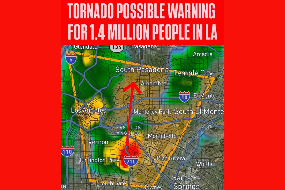
Severe Thunderstorm Warning With a Tornado Possible Tag Covers 1.4 Million People in East Los Angeles, Alhambra and South Gate in California
LOS ANGELES, CA — A Severe Thunderstorm Warning carrying a tornado possible tag was issued for a densely populated section of Los Angeles County, covering an estimated 1.4 million people in South and East Los Angeles and the western San Gabriel Valley. The warning remained in effect until 10:45 AM PDT as a strong thunderstorm moved north from near Interstate 710, prompting urgent calls for residents in its path to seek shelter immediately.
What a Tornado Possible Tag Means
A Severe Thunderstorm Warning is issued when a storm is producing or is about to produce damaging winds or large hail. When the National Weather Service adds a tornado possible tag, it means the storm is showing signs of rotation that could briefly produce a tornado, even though the threat is not strong enough to issue a full Tornado Warning.
In a region where tornadoes are uncommon, this type of alert is a serious signal. Tornadoes in Southern California are usually brief and weak, but in heavily populated neighborhoods, even a short-lived tornado can cause damage to homes, trees, and power lines.
Storm Tracking North Through East Los Angeles
Radar showed the strongest part of the storm, marked by red and orange returns, near Interstate 710 between Huntington Park and East Los Angeles. The storm was moving north, toward Monterey Park, Alhambra, and South Pasadena.
Heavy rain extended across nearby areas, including Vernon, Huntington Park, and the eastern edge of Downtown Los Angeles, with additional showers spreading toward Glendale and Pasadena.
Communities Inside the Warning Area
The warning polygon covered a broad stretch of the Los Angeles Basin and San Gabriel Valley. Communities included Los Angeles, East Los Angeles, South Gate, Vernon, Huntington Park, Montebello, Monterey Park, Alhambra, South Pasadena, Temple City, El Monte, and South El Monte.
Areas near Pico Rivera, Downey, Whittier, Santa Fe Springs, and Arcadia sat close to the edges of the warning and were also urged to stay alert.
Part of an Active Storm Pattern
This warning follows a week of unusually active weather across California and the Southwest. A strong storm system brought heavy rain, thunderstorms, waterspouts, and mountain snow across Southern California, while forecasters had highlighted the potential for rotating storms along the coast and in the Los Angeles area.
The setup of cold air aloft, moisture, and wind shear has made rotating storms more likely than usual for the region.
Safety Steps During a Warning
Residents in the warning area should move indoors to a sturdy building and go to an interior room on the lowest floor, away from windows. Drivers should avoid flooded roads, as heavy rain can quickly overwhelm storm drains and freeway underpasses.
Anyone outdoors should seek shelter immediately, as lightning, strong winds, and possible hail can develop quickly in severe storms.
Updates to Follow
Any reports of tornado touchdowns or storm damage will be reviewed by the National Weather Service. Residents should continue monitoring official alerts as additional storms move through the region.
For continuing coverage of California severe storms, tornado alerts, and critical weather analysis across the United States, visit Weather Radar.