Grant and Hidalgo Counties in Southwest New Mexico Receive First Tornado Warning in Over 40 Years as Rotating Storm Moves Near Redrock Thursday
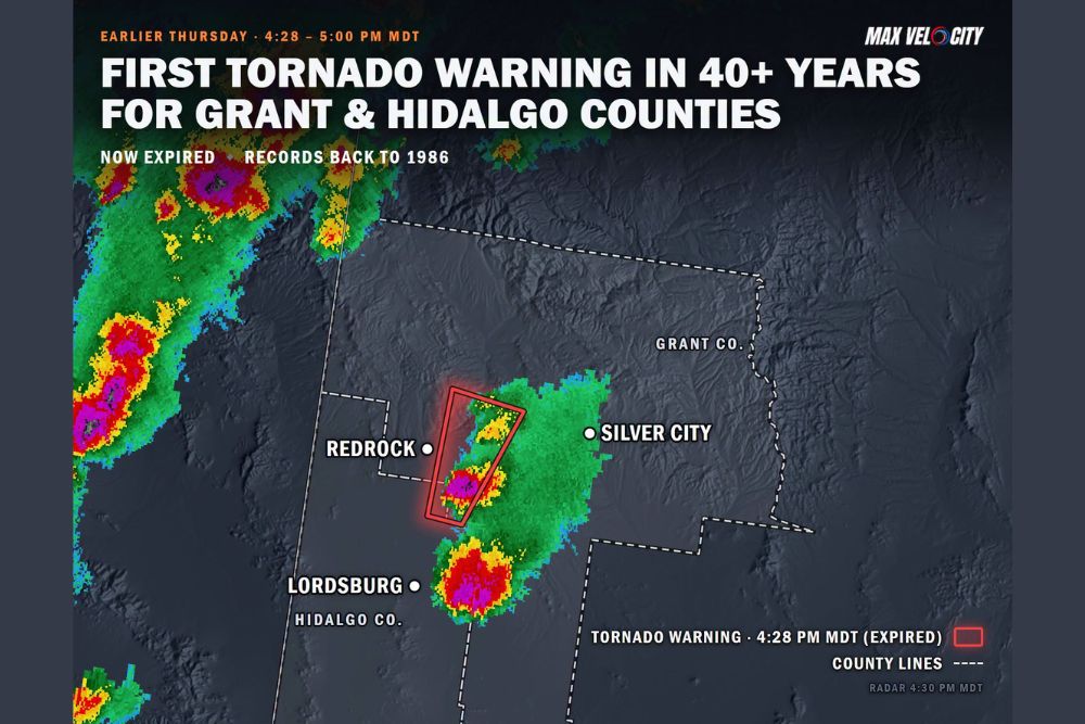
SILVER CITY, NM — Southwest New Mexico made weather history on Thursday, October 22, as Grant County and Hidalgo County were placed under their first tornado warning in at least 40 years. The warning was issued at 4:28 PM MDT and remained in effect until 5:00 PM MDT for a strong thunderstorm near Redrock, located between Lordsburg and Silver City. Warning records for the area date back to 1986, and no previous tornado warning had been issued for these counties during that time.
A Historic Warning for the Region
Tornado warnings are extremely rare across southwest New Mexico, where the rugged terrain and dry climate rarely support the type of rotating storms needed for tornado development. The warning for Grant and Hidalgo counties marks a notable milestone in the region’s weather records.
The warning has since expired, and there were no immediate confirmed reports of a tornado touchdown. Any official determination will depend on reports and surveys from the National Weather Service.
Storm Location Near Redrock
Radar imagery from 4:30 PM MDT showed a strong thunderstorm positioned just east of Redrock, near the boundary between Grant and Hidalgo counties. The narrow warning polygon stretched from south of Redrock northeastward, covering the area of greatest concern for possible rotation.
The storm displayed intense radar returns, with deep red and magenta colors indicating very heavy rainfall and possible hail within its core. The storm was part of a broader cluster of thunderstorms moving across the region.
Additional Strong Storms Nearby
Another intense storm cell was located just north of Lordsburg in Hidalgo County, showing similarly strong radar returns. Additional strong thunderstorms were also visible farther west near the Arizona border, where heavy rainfall and possible hail were indicated.
Silver City sat just east of the main storm area, where lighter rain and scattered showers extended across portions of Grant County.
Part of an Unusual Severe Weather Week in the Southwest
The warning comes during an exceptionally active stretch of severe weather across the Southwest. Earlier in the week, a tornado was observed near Deming in Luna County, while multiple tornado warnings were issued across Arizona, including a rare anticyclonic storm near Show Low.
An unusual combination of moisture, instability, and strong wind shear has allowed rotating thunderstorms to develop across a region that typically sees very few tornado-producing storms, especially in late October.
Safety Reminders for Residents
Because tornado warnings are so uncommon in southwest New Mexico, many residents may be unfamiliar with safety procedures. During a warning, residents should move to an interior room on the lowest floor of a sturdy building and stay away from windows. Drivers should avoid traveling into storms and seek shelter if conditions worsen.
Residents are encouraged to enable Wireless Emergency Alerts on their phones and keep a weather radio available during active weather periods.
Monitoring Continues
Forecasters will continue watching for additional storms across the region as the active pattern persists. Any damage reports should be shared with local authorities and the National Weather Service.
For continuing coverage of severe storms, tornado warnings, and critical weather analysis across the United States, visit Weather Radar.