Rare Level 3 Severe Risk Targets Flagstaff, Sedona and Prescott in Arizona Wednesday as Tornadoes, Tennis Ball Hail and 70 MPH Gusts Threaten
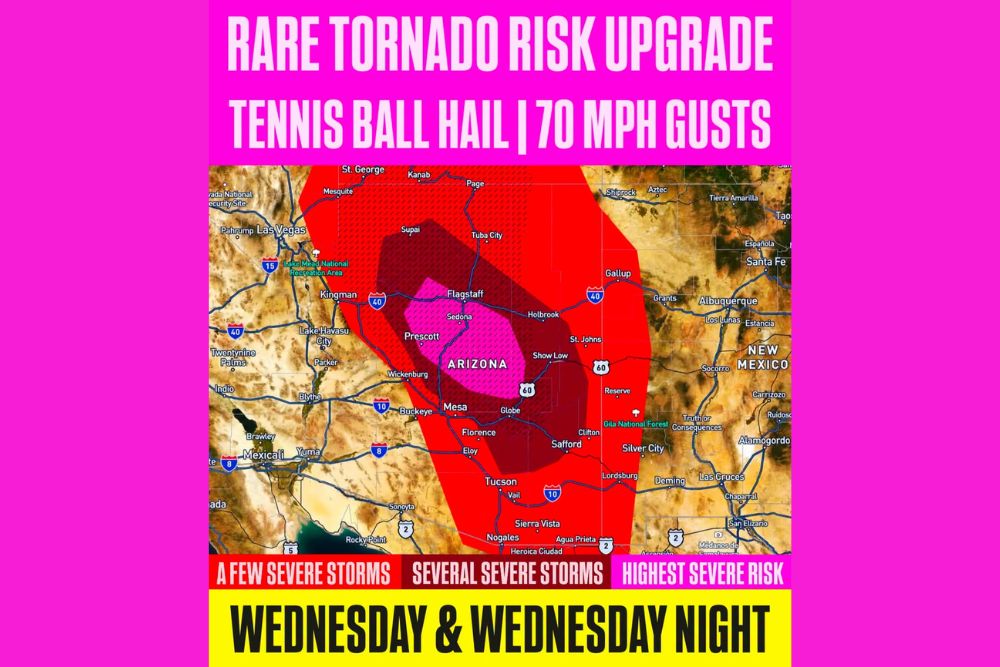
FLAGSTAFF, AZ — A rare and potentially dangerous severe weather setup is unfolding across Arizona on Wednesday and Wednesday night, with a Level 3 out of 5 severe risk now highlighted for central portions of the state. A regional severe weather outbreak is increasingly likely, with storms capable of producing tornadoes, tennis ball size hail, and damaging wind gusts up to 70 mph. Severe risks of this level are highly unusual for Arizona, making this an exceptional event for the region.
Highest Risk Centered on North Central Arizona
The highest severe risk zone is focused on north central Arizona, covering Flagstaff, Sedona, and Prescott, along with surrounding communities along the Mogollon Rim. This area has the greatest potential for destructive storms, including the strongest tornadoes and largest hail.
A broader area rated for several severe storms surrounds this zone, stretching from near Supai and Tuba City south through Holbrook, Show Low, Mesa, Globe, Florence, and Safford. Residents across the Phoenix metro area, including Mesa, should stay alert throughout the day.
Wide Area at Risk Across the Southwest
A larger zone for a few severe storms extends across nearly all of Arizona and into parts of neighboring states. This area includes Kingman, Lake Havasu City, Wickenburg, Buckeye, Tucson, Sierra Vista, and Nogales, as well as southern Utah near St. George and Kanab.
In New Mexico, the risk area extends to communities near Gallup, Shiprock, Silver City, and Lordsburg, while far western portions near Las Vegas, Nevada, and Mesquite also sit along the edge of the outlook.
Tornado Threat Increasing
The tornado risk has been upgraded as forecasters see a stronger combination of moisture, instability, and wind shear than is typical for the region. A hatched area on the outlook highlights where the potential exists for significant severe weather, including stronger tornadoes.
Tornadoes in Arizona are relatively rare, and many residents may not be familiar with tornado safety procedures. Anyone in the risk area should identify a safe shelter location ahead of time, ideally an interior room on the lowest floor away from windows.
Large Hail and Damaging Winds
The strongest storms could produce hail as large as tennis balls, roughly 2.5 inches in diameter. Hail of this size can shatter windows, damage roofs, destroy crops, and seriously injure people or animals caught outdoors. Drivers should seek covered parking if storms approach.
Damaging wind gusts up to 70 mph are also possible, capable of downing trees, snapping power poles, and causing structural damage. Power outages may occur in areas hit by the strongest storms.
Storms Continue Into Wednesday Night
Severe storms are expected to continue into Wednesday night, raising concerns about tornadoes and damaging winds occurring after dark. Residents should make sure phones are set to receive Wireless Emergency Alerts and keep a weather radio nearby.
Heavy rain may also lead to flash flooding in normally dry washes and low-lying areas, especially near burn scars and canyons.
Stay Weather Aware
This is a high-impact event for Arizona, and official watches and warnings from the National Weather Service should be taken seriously. Conditions are expected to improve on Thursday as the storm system moves east.
For continuing coverage of severe storms, tornado alerts, and critical weather analysis across the United States, visit Weather Radar.