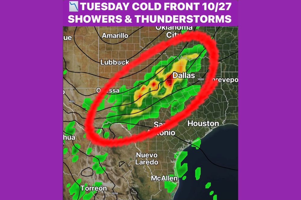
Next Cold Front Brings Showers and Thunderstorms to Dallas and North Texas on Tuesday, October 27, Adding to a Wet October Rainfall Total
DALLAS, TX — The next meaningful rain chance for North Texas is set to arrive on Tuesday, October 27, as a cold front pushes into the region and brings a line of showers and thunderstorms with it. While the front is still about a week away and details remain uncertain, early model guidance shows a broad band of rain stretching across much of Texas. The system could add to what has already been a wet October at Dallas/Fort Worth International Airport, where 3.94 inches of rain has been recorded so far this month.
A Line of Storms Along the Cold Front
Forecast guidance shows a band of showers and thunderstorms forming along and ahead of the cold front as it moves through the state. The rain shield stretches from near Odessa in West Texas northeastward through Central Texas and into the Dallas-Fort Worth Metroplex, extending toward southern Oklahoma near Oklahoma City.
Some of the strongest returns on the model output appear near Dallas and across portions of North Central Texas, where pockets of heavier rain and embedded thunderstorms are shown. Lighter showers are also possible farther south toward San Antonio and the Hill Country.
Timing and Intensity Still Uncertain
With the front still about a week away, it remains too early to determine precise timing, storm intensity, and rainfall amounts. The speed of the front, the amount of moisture available, and the strength of the upper-level energy will all influence how much rain falls and where the heaviest storms develop.
Residents should expect forecast details to change in the coming days as new model data arrives. More confidence in the timing and possible severe weather risk should become clearer by the weekend.
October Started and Ends on the Wet Side
October began on the wet side across North Texas, and it now appears the month could end the same way. The 3.94 inches of rainfall recorded at DFW Airport so far this month is a solid total, and the late-month cold front could push that number even higher.
The additional rain would be welcome for lawns, gardens, and local water supplies, especially as the region heads into the cooler months. Any heavier storms could also bring brief periods of ponding on roadways and reduced visibility for drivers.
Areas Outside the Main Rain Band
Locations farther west, including Lubbock and Amarillo, sit on the drier side of the system based on current guidance. Similarly, Houston and much of Southeast Texas appear to fall outside the main rain band, though scattered showers remain possible near the coast.
Deep South Texas, including McAllen and Nuevo Laredo, shows only isolated activity at this time. The placement of the rain band could shift, so residents across the state should keep checking forecasts.
Cooler Air Expected Behind the Front
Cold fronts this time of year often bring a noticeable drop in temperatures and humidity once they pass. Residents can expect cooler and drier air to settle in behind the front, giving North Texas a taste of more seasonal fall weather.
What Residents Should Do Now
For now, residents across North Texas should keep an eye on the forecast for Tuesday, October 27, especially if outdoor plans, travel, or events are scheduled. Updates on timing and potential storm strength will become more detailed as the front approaches.
For continuing coverage of cold fronts, Texas rain chances, and critical weather analysis across the United States, visit Weather Radar.