Offshore Storm Brings Gusty Winds, Rough Surf and Coastal Flooding to Maryland and Delaware Beaches Wednesday as Baltimore Stays Cool and Breezy
OCEAN CITY, MD — A developing coastal storm off the East Coast is bringing increasing winds, rough surf, and coastal flooding concerns to the beaches of Maryland and Delaware on Wednesday, October 21. While the center of the storm will remain well offshore, its broad wind field is large enough to affect the coastline. Inland areas such as Baltimore will see a much smaller impact, with cooler temperatures and a noticeable breeze marking a shift in the weather pattern rather than a major storm threat.
A Mild Tuesday Before the Change
Baltimore enjoyed another mild October day on Tuesday, reaching a high of 72 degrees with a peak wind gust of 27 mph. Conditions were already more active farther east, where Ocean City recorded wind gusts approaching 40 mph as the offshore storm began to organize.
Wednesday will feel noticeably cooler across the region as the storm’s circulation pulls drier air southward, while the strongest winds remain focused near the Atlantic beaches.
What Is Happening Offshore
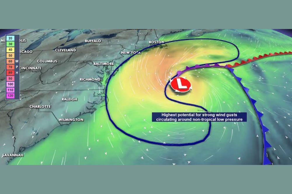
An area of low pressure is developing over the Atlantic Ocean, east of the Mid-Atlantic coastline. The National Hurricane Center has identified this area with a 40 percent chance of tropical development over the next 2 to 7 days, placing it in the medium chance category.
However, the storm affecting the region on Wednesday is expected to remain non-tropical. Its broad circulation is capable of producing strong winds and rough surf across a wide stretch of the coastline. ECMWF model guidance shows the system pulling farther out into the Atlantic by Thursday afternoon.
Coastal Flood Advisories in Effect
Coastal Flood Advisories are posted for portions of the Maryland Eastern Shore and Delaware, including areas near Ocean City, Salisbury, Georgetown, and Dover. Additional coastal areas of southern New Jersey, including communities near Atlantic City, are also highlighted.
Persistent onshore winds will push Atlantic water toward the coast, increasing the potential for tidal flooding in vulnerable low-lying areas. The greatest concerns include minor coastal flooding around high tide, water covering some low-lying roads, and dangerous surf conditions near the beaches.
Wind Outlook Across the Region
In Baltimore and Central Maryland, conditions will be cooler and breezy, but the strongest winds should stay well to the east. On the Eastern Shore, winds will increase steadily, especially closer to the Atlantic beaches.
Ocean City and the Delaware beaches will face the most significant impacts, with gusty winds, rough surf, and elevated water levels as the primary concerns. The highest potential for strong wind gusts will remain over the open waters circulating around the non-tropical low.
Wider Coastal Flooding Threat Along the East Coast
The coastal flooding potential extends beyond Maryland and Delaware. An increased coastal flooding threat stretches along the Atlantic shoreline from New York and New Jersey south through Virginia Beach, Kill Devil Hills, and toward Wilmington, North Carolina.
Dry Weather and Warming Ahead
Once the storm pulls away, the region is expected to stay dry, with another warmup arriving next week. That means continued focus on drought conditions, which remain a concern across much of Maryland.
For continuing coverage of coastal storms, flood alerts, and critical weather analysis across the United States, visit Weather Radar.