Backdoor Front Brings Gusty East Winds and Low 70s to Alabama and Tennessee This Weekend Before a Strong Cold Front Arrives Ahead of Halloween
HUNTSVILLE, AL — The forecast for the Tennessee Valley is showing some interesting changes as Halloween approaches, with two weather systems expected to bring cooler temperatures and a noticeable shift in conditions across North Alabama and Southern Tennessee. A backdoor cold front pushing in from the east this weekend could create a wedge of cooler air, followed by a strong cold front around midweek that may deliver windy conditions and another significant temperature drop just ahead of the holiday.
Backdoor Front Brings Cooler Air This Weekend
The first system is a backdoor cold front, a less common type of front that moves in from the east or northeast rather than the typical west or northwest direction. As it pushes into the region, it could set up a wedge of cooler air across the Tennessee Valley this weekend.
This setup will bring a stronger east wind, with gusts of 15 to 20 mph possible on both Saturday and Sunday. The breezy easterly flow will help hold afternoon highs in the lower 70s across much of the region.
Saturday Afternoon Temperatures
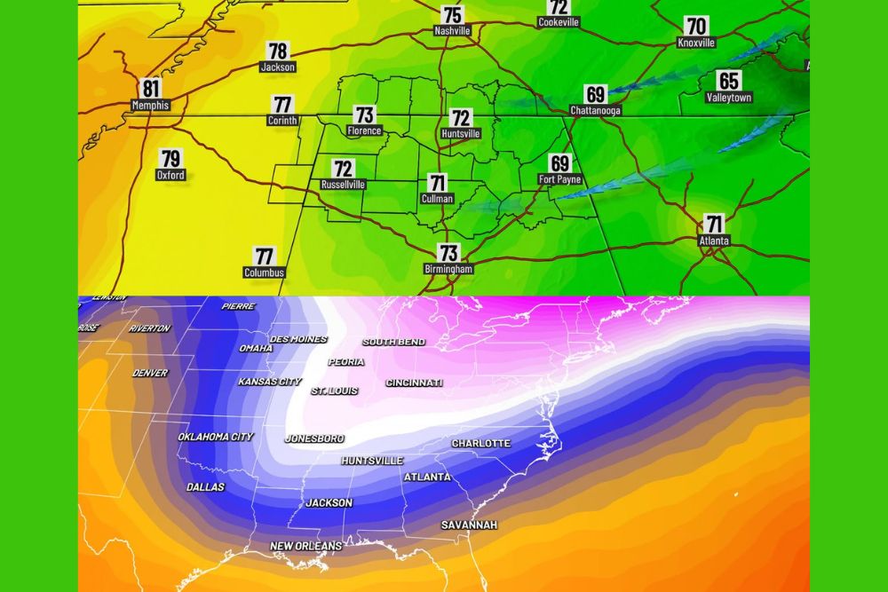
Forecast temperatures for Saturday, October 24, at 5:00 PM show a clear contrast from east to west. Huntsville is expected to reach around 72 degrees, while Florence climbs to 73 degrees and Russellville reaches 72 degrees. Cullman sits near 71 degrees, with Birmingham around 73 degrees and Fort Payne near 69 degrees.
In Tennessee, Nashville is forecast near 75 degrees, Cookeville around 72 degrees, Knoxville near 70 degrees, and Chattanooga about 69 degrees. Areas farther west, outside the cooler wedge, will stay warmer, with Memphis reaching 81 degrees, Oxford near 79 degrees, and Jackson, Tennessee, around 78 degrees.
Even Cooler on Sunday
The cooler wedge strengthens slightly by Sunday, October 25. At 1:00 PM, Huntsville is forecast near 70 degrees, Cullman around 69 degrees, Fort Payne near 68 degrees, and Birmingham around 71 degrees. Chattanooga holds near 69 degrees, while Valleytown drops to about 66 degrees.
Western areas also cool a bit, with Memphis near 76 degrees and Oxford, Columbus, Corinth, and Jackson all around 75 degrees.
Warmup Ahead of a Strong Midweek Cold Front
A warmup is expected early next week as south winds increase ahead of a strong cold front arriving around Wednesday, October 28. Jet stream forecasts show a deep dip in the jet stream extending from the Plains into the Mid-South, signaling a significant push of colder air.
This front could bring windy conditions and another significant drop in temperatures just ahead of Halloween, setting up a much cooler feel for trick-or-treating across the region.
Rain Chances Depend on Timing
Rain chances with the midweek front remain uncertain. If the front arrives on Wednesday, available moisture may be limited, resulting in little rainfall. However, if the front slows down and arrives late Thursday or Friday, there could be a better chance for some much-needed rain across the Tennessee Valley.
The exact timing will be key, and forecasters will continue monitoring the system closely over the next several days.
Planning Ahead for Halloween
Residents with outdoor plans this weekend should expect breezy conditions and comfortable temperatures. Families preparing for Halloween events should keep an eye on updated forecasts, as cooler and windier weather could arrive just before the holiday.
For continuing coverage of fall cold fronts, Halloween forecasts, and critical weather analysis across the United States, visit Weather Radar.